Saturday, December 17, 2016

UPDATE: Slight Risk for Severe Weather Saturday, Dec. 17th

NOTE: This blog post is pertaining to a chance for severe weather that is forecast for today, Saturday, December 17th, 2016.

Well, here we are! Winter one day, Spring the next! Temperatures have warmed up even quicker than expected reaching near 70°F in some places here at 9:15am thanks to the surprise sunshine we've had this morning. That was something I really wasn't expecting us to have much of today, but it could lead toward a more enhanced risk for severe weather tonight.


We haven't had much rain so far and it doesn't look like we'll see much more in West Tennessee until this afternoon. So if you're trying to get some errands done before the holidays, the morning and early afternoon is going to be the best time to do it because after 3 or 4pm we'll start seeing the risk for severe weather increase.


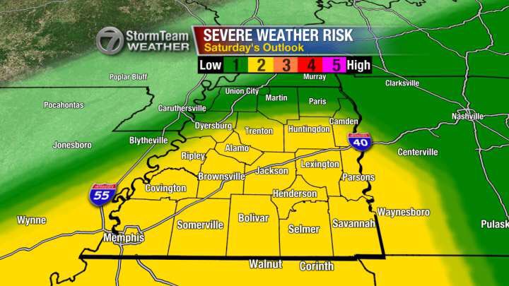
Right now, there's a slight risk for severe weather in all of West Tennessee for this afternoon and evening. That may be upgraded to an enhanced risk later this morning or afternoon. The main threats are still for damaging winds and flash flooding in any thunderstorms that become severe, but the possibility for an isolated tornado is increasing.


Make sure you have a viable way of receiving alerts on your cell phone in case tornado watches or warnings are issued! Here's one way


Right now, the latest weather models are showing the greatest risk for severe weather in Jackson occurring between 5pm and 9pm. Between 7pm and 8pm, this data shows the temperature in Jackson dropping 15°F!


This animated loop shows you what the radar may look like later today. The strongest storms will start developing in northwest Tennessee this afternoon between 2 and 4pm but may not finally leave West Tennessee near Savannah until between 11pm and 1am.


You'll notice toward the end of the lapse, that an ominous purple color shows up. That's the freezing rain and sleet we'll see on the back edge of the rain as colder air crashes in. We're still not expecting anything significant regarding snowfall tonight. Sure, we might see a few snowflakes but don't expect it to stick much if at all.


Ice, on the other hand, could be a problem, especially for the eastern half of West Tennessee. The image below shows the probability for 0.10" of ice to accumulate. That wouldn't really be enough to cause power lines to come down but could accumulate on elevated roadways and overpasses to create a few slick spots on Sunday morning. In addition to freezing rain and sleet, some puddles of rain could freeze with temperatures in the mid 20s by Sunday morning.


Stay weather-aware today, West Tennessee. We're about to see quite a change over the next several hours!

Summary:


  • Severe weather will be possible today during the later hours of the afternoon and evening. Savannah may still have strong thunderstorms around midnight.
  • Temperatures will drop sharply after the cold front comes through
  • Freezing rain and sleet are a real possibility and could cause some hazardous travel in some areas after midnight into early Sunday morning.

Friday, December 16, 2016

Slight Risk for Severe Weather Saturday, Dec. 17th

NOTE: This blog post is pertaining to a chance for severe weather that is forecast for today, Saturday, December 17th, 2016.

Temperatures have already reached the upper 40s in parts of West Tennessee this afternoon now that we have winds from the south gusting between 20 and 25 miles per hour. If anything, this should tell you that our warm-up has begun and is still forecast to continue into Saturday when high temperatures tomorrow could reach the lower to middle 70s!


The two big question that remain are: 1) Will we get severe thunderstorms Saturday afternoon and evening? and 2) Could the cold air catch up to the rain quickly enough to bring freezing rain, sleet, or snow to West Tennessee?

Here's what we know so far...

The Storm Prediction Center with the National Weather Service has upgraded our risk from marginal (1 out of 5) to slight (2 out of 5) so the possibility for a severe thunderstorm tomorrow is looking more likely than it did yesterday for Mississippi and parts of West Tennessee.
Media preview

The main threats with any storms that become severe tomorrow are with a possibility for damaging winds and an isolated tornado but flash flooding may also occur now that the ground is more saturated from recent rainfall.

As far as timing is concerned, we'll see rain move into West Tennessee tonight and tomorrow morning but the best chance for any strong to severe thunderstorms will occur between the late afternoon and the late night hours, not ending in Savannah until midnight or 1 a.m. Sunday morning.


You may notice that some of that rain does change over to a wintry mix briefly as the front crosses the Tennessee River. The possibility for West Tennessee to see any freezing rain or sleet is there, but it still does not look like we'll see much if any accumulation. At the very most, there might be a light coating of ice on your car or on tree branches Sunday morning, but with minimal impact to our ability to travel. In Middle Tennessee, the possibility for accumulating ice is higher.

So to summarize:

  • Best possible outcome with our weather this weekend is that we get some wind and rain with a brief period of freezing rain or sleet between Saturday night and Sunday morning.
  • Worst case scenario is that in addition to the wind and rain, we have severe thunderstorms producing an isolated tornado with a brief period of freezing rain or sleet between Saturday night and Sunday morning.
Stay weather aware tomorrow! If you have any errands to run this weekend, Saturday morning and early afternoon will be the best time to get things done! Don't forget to tie down those Christmas decorations down tonight too!

I'll keep you posted with another update on WBBJ 7 Eyewitness News!

Sunday, December 4, 2016

Will West Tennessee Get Snow This Week?

NOTE: This blog post is pertaining to the cold air coming with a chance for rain on Wednesday night and Thursday morning, December 7th to December 8th, 2016.

The title of this post seems to be the big question I've been getting in my inbox this weekend. Here we are on December 4th, Christmas Day is 3 weeks away! So where's the snow? Well...


...the interactive radar on our website (www.wbbjtv.com/weather/interactive-radarshows quite a bit of snow falling over parts of Michigan and the Great Lakes region today. But to really answer your question...


The chart above shows the first and last measurable snowfall dates for Jackson over the years for each winter, dating back to the late 1800s. Each blue bar is drawn for dates between when the first snowfall was recorded to when the last snowfall was recorded. This tells us that
, on average, our first snowfall for Winter happens on January 11th and the last snowfall happens on February 5th. You'll notice that there are some years missing so...


Here's a second chart from a different station in Jackson with data going back to the mid 1900s. In this dataset the numbers tell us that, on average, our first snowfall happens on January 5th and the last snowfall happens on February 14th.

In other words, we don't see snow in December very often. We see it more during January and February. Nevertheless, in the last decade (2006-2015) we've had snow in 9 out of 10 
Decembers whether that was as few as just one day of that month or 5 days out of that month of measurable snowfall.

Regarding the chance for snow everyone is talking about for later this week, I've been receiving references to forecasts from a certain cable station and from the National Weather Service calling for snow this week on Wednesday night (December 7th) into Thursday morning (December 8th). But there's a reason why we don't get measurable snowfall very often in December. Among many other reasons, one is that the ground is too warm!


Even right now, a website called greencastonline.com shows our soil temperatures in West Tennessee between 40° and 50°F! Snow doesn't stick to that.


What we have setting up on Wednesday night into Thursday morning is a slight chance for rain being chased by cold air coming straight down from Alaska. In some cases that rain could change over to snow, but that doesn't look likely for us this time. If it does end up happening, we could see some flurries but nothing that will impact travel too much.

There were definitely times that some of the computer models showed snow sticking on Thursday but there are some problems with these models. More often than not they show nothing sticking for West Tennessee.


So stay with us as we monitor this system. Our job is to prepare - not scare! We're certainly aware of the fact that some people like the idea of snow falling before Christmas (I'm one of them!) but we're not going to just tell you what you want to hear! We want to be accurate and trustworthy for our viewers so that we can be depended upon when weather makes getting out on the roads a hassle.

That's our goal. Thanks for watching!

Tuesday, November 29, 2016

Enhanced Risk for Severe Weather Tuesday, Nov. 29th

NOTE: This blog post is pertaining to a chance for severe weather that is forecast for tonight, the night of Tuesday, November 29th, 2016.
Do you feel that? The warm winds are blowing! Before the weather station at the McKellar-Sipes Regional Airport began to malfunction again, it was reporting temperatures in the lower 70s at 10 a.m. this morning! This along with other ingredients in the atmosphere could set us up for severe weather tonight.

All of West Tennessee is looking at a chance for rain tonight, but not everyone is expecting severe weather. The slight to enhanced risk for severe thunderstorms is for areas in West Tennessee south of I-40 in addition to parts of Carroll and Benton counties.


On a regional view of the radar, you can see the storms starting to develop in Louisiana. They'll continue moving northeast this afternoon into Mississippi ultimately ending up in portions of Alabama and Tennessee tonight.


This animated image shows what the storms may look like on radar here locally...


...we're expecting the main threat for severe weather in West Tennessee to start as storms enter the area between 6 and 7pm. While there may still be some rain lingering overnight into Wednesday morning, the risk for severe weather will deteriorate between 12 a.m. and 2 a.m. Wednesday morning.

The thunderstorms that develop tonight will mainly pose a threat for damaging winds and hail but a tornado will also be possible tonight - especially the areas under the enhanced risk. That includes Hardeman, McNairy, and Hardin counties but parts of Chester, Henderson, and Decatur counties are in that area as well.

Stay with us as we monitor the storms this evening. We'll be sure to relay any information regarding watches and warnings issued by the National Weather Service.

RECAP:

  • Strong to severe thunderstorms possible tonight
  • Greatest risk for severe weather is south of I-40
  • Damaging winds are the main threat but tornadoes are also possible
  • Storms are expected to be worst between 6 p.m. Tuesday and 2 a.m. Wednesday

Monday, November 28, 2016

Slight Risk for Severe Weather Monday, Nov. 28th

NOTE: This blog post is pertaining to a chance for severe weather that is forecast for today, Monday, November 28th, 2016.

West Tennessee continues to get some off-and-on rain this morning with windy conditions. There's plenty more coming. A wind advisory is in effect until 6pm today for all of West Tennessee.


All of West Tennessee is under a slight risk for severe weather today. The main threat is for damaging winds (gusts over 60mph) but hail and an isolated tornado cannot be ruled out.


There is an enhanced risk for severe weather in Northern Mississippi and points south where the possibility for tornadoes is a little higher.


We'll continue to see rain & wind this morning but the strongest storms will be coming this afternoon. Here's a quick look at them in what the radar may show us later today. Notice the dark red line? That's a squall line - a line of strong winds.


Here's a time table for the day. Thinking Jackson will get the worst of it between 3 and 5pm, but especially right around 4 o'clock.


RECAP:

  • Severe storms possible after noon. 
  • Damaging winds will main threat. 
  • Small possibility for isolated tornado in West Tennessee.
I'll continue to keep you posted on Facebook and Twitter throughout the day!

Facebook: https://www.facebook.com/WBBJ.tom.meiners
Twitter: https://twitter.com/WBBJ7TomMeiners

Wednesday, April 27, 2016

Slight Risk for Severe Weather Today, Wednesday, April 27th 2016

NOTE: This blog post is pertaining to a chance for severe weather that is forecast for today, Wednesday, April 27th, 2016.

Regional radar currently shows us the line of storms that moved through the Plains last night, and that it survived the trip across Arkansas now approaching West Tennessee.


A closer look reveals even a few isolated storms in northwest Tennessee early this morning. So far, as of 7:44 a.m. none of these storms or the storms to our west are going severe but we'll be monitoring as that is a small possibility.


However, the latest model data, which you can see below, suggests that as those storms continue to move northeast into West Tennessee, that they weaken and gradually dissipate across our area. This would be round 2 of the storms with a 3rd round of scattered activity during the afternoon and drier weather after sunset tonight.


The rain we get from this next wave could help stabilize the atmosphere more for the afternoon preventing us from seeing severe weather, but that's impossible to set in stone. There are still a lot of uncertainties, but overall, our risk for severe weather remains relatively low - a 2 out of 5.


If any thunderstorms DO become severe today, the main threats will be with severe thunderstorms that could produce large hail and damaging winds. The threat for an isolated tornado continues to look very low.


HIGHLIGHTS
  • Rain moving into West Tennessee now may keep our severe weather risk to a minimum today
  • Still under a slight risk (2 out of 5) for severe weather across the area
  • Main concern still lies with large hail and damaging winds if any scattered thunderstorms develop during the afternoon

Tuesday, April 26, 2016

Tuesday Afternoon UPDATE: Severe Weather Threat for Wednesday, April 27th, 2016

NOTE: This blog post is pertaining to a chance for severe weather that is forecast for Wednesday, April 27th, 2016.

As of 12:30 p.m. on Tuesday, April 26th, 2016, we've stayed dry so far in West Tennessee but an isolated shower or thunderstorm will be possible this afternoon.

We're monitoring a complex of showers and thunderstorms across Central Missouri that will be moving into northwest Tennessee between 6 p.m. and 8 p.m. tonight (Tuesday).


When they get here, there's a marginal risk (1 out of 5) for severe weather in northwest Tennessee - mainly north of Interstate 40. However, showers and thunderstorms will be possible anywhere in West Tennessee tonight as the line of rain moves southeast across the area. The main threat will be for damaging winds and large hail with this line, but as it approaches Jackson and moves farther southeast, storms are expected to weaken.


On the regional radar image above, you can see that storms have already begun to form out to our west across Oklahoma. That will be the next round of storms to move into West Tennessee, and they're expected to arrive Wednesday morning. Depending on when they get here, they could bring strong to severe thunderstorms in West Tennessee with a risk for damaging winds and large hail. An isolated tornado is possible but that chance remains low.


Again, depending on timing, things could change with those threats. If this line comes in early Wednesday morning. The atmosphere may be able to recover giving us a chance for scattered thunderstorms during Wednesday afternoon and evening resulting in another round of potentially severe weather.

Stay with the VIPIR 7 Storm Team for more updates and stay prepared!

HIGHLIGHTS
  • Isolated thunderstorms this afternoon with a more widespread line of rain and occasional thunder moving into northwest Tennessee between 6pm and 8pm
  • Next wave arrives Wednesday morning with a slight risk for severe weather
  • Potentially looking at another round of storms tomorrow afternoon and evening but won't know more until tonight
  • Main threats are for damaging winds and large hail with each round but an isolated tornado won't be out of the realm of possibility

Monday, April 25, 2016

Severe Weather Threat for Wednesday, April 27th, 2016

NOTE: This blog post is pertaining to a chance for severe weather that is forecast for Wednesday, April 27th, 2016.

Right now, (as of 9:15pm, Monday April 25th) much of the western half of West Tennessee has been placed under a slight risk for severe weather with the rest of West Tennessee under a marginal risk. 


Timing is still difficult to nail down, so we'll have to be prepared for strong to severe thunderstorms during the morning, afternoon, evening, and potentially late at night. We'll be able to get a better handle on when the storms will move in and develop in the area once they start to generate out west tomorrow.

All the ingredients seem to be present to provide us with a risk for strong to severe thunderstorms. Energy seems to be the most available, with a decent amount of moisture and shear. One of the elements found lacking a bit from the environment will be "lift" which may end up being difficult to predict in this situation. Lift is essential to having thunderstorms, or really any rain for that matter. This will also be easier to pinpoint whether that element will be available once the storms begin to develop.


Main concerns will lie with a risk for damaging winds and large hail but an isolated tornado will also be possible, especially during the later hours of the day. Right now, the threats are low to medium, but if the timing of these storms lines up with having more ingredients available, those threats will increase.


We'll keep you updated, but make sure to be prepared for severe weather by having a way to receive weather alerts whether that be with a NOAA Weather Radio, your smartphone, or from someone who can call you with that information.

HIGHLIGHTS
  • There will be a potential for severe weather that may come in more than one round on Wednesday, April 27th, 2016.
  • Timing is still difficult to nail down but we'll know more about these storms tomorrow once they develop well to our west in the Plains.
  • Damaging winds and large hail are the main threats, but an isolated tornado is worth preparing for too.
  • Make sure you have a way to get watches and warnings when they're issued from the National Weather Service!

Wednesday, March 30, 2016

Severe Weather Risk Wednesday Night and Thursday

NOTE: This blog post is pertaining to a chance for severe weather that is forecast for the NIGHT of Wednesday, March 30th and early MORNING of Thursday, March 31st. In addition, this post discusses the chance for severe weather that is forecast for the AFTERNOON and EVENING of Thursday, March 31st.

I'll begin with what we know right now, and that is that West Tennessee is under a marginal (1 out of 5) to slight (2 out of 5) risk for severe weather from right now, through 7 a.m. Thursday morning.


From 7 a.m. Thursday to Thursday evening, West Tennessee is under an enhanced (3 out of 5) risk for severe weather.


This means that there will be a low to low-medium chance for strong to severe thunderstorms tonight mainly near the Mississippi River (points southwest of Jackson) but on Thursday all of West Tennessee has a medium risk for severe weather.

Rain will begin to appear over West Tennessee during this (Wednesday) afternoon and evening. Short term model data is pointing to that and has been for some time. Severe weather is unlikely at this time but a thunderstorm could take shape. Below you'll see how the rain is scattered at the beginning of the loop (during the evening) but late at night (9pm Wednesday into early Thursday morning) the rain becomes more widespread and HEAVY. Plus, the risk for severe weather increases slightly.


There is a FLASH FLOOD WATCH in effect for much of southwest Tennessee. The counties colored in green are under the watch because they have a chance for 2"-4" of rain to fall over the next 36 to 48 hours. Some may see even more than that. (Sorry the image is a little blurry)


Flooding is the main concern for West Tennessee Wednesday night into Thursday morning. However, we'll be keeping an eye on the risk for a severe thunderstorm to move into West Tennessee from the southwest where damaging winds, large hail, and an isolated tornado will be possible. This would be likeliest after midnight and into the early morning on Thursday.

The rain will come to an end in West Tennessee sometime after daybreak Thursday, but the risk for severe weather and the chance for rain will return through the afternoon and evening hours.

Yesterday (Tuesday) on WBBJ 7 Eyewitness News, I mentioned that I was uncertain about the timing of the cold front on Thursday. If it came through early, then our risk for severe weather wouldn't be too significant but we would still need to be on alert for Flash Flooding.


I was worried that the front might come in later though, and that continues to appear the direction this weather forecast is heading. Based on that trend, and the available ingredients for storms there will be a risk for damaging winds, large hail, and a few tornadoes in West Tennessee Thursday afternoon and evening.


The calendar says late March, so a discussion regarding a risk for severe weather is not uncommon this time of year. In fact, a recent study of climatology in the Mid-South by the National Weather Service in Memphis revealed that March is the 2nd most active month for deadly tornadoes and the 3rd most active month for all tornadoes.


That said, you absolutely NEED to be weather aware for the next 36 to 48 hours! Make sure you have a way to receive alerts including tornado watches and warnings and all other forms of breaking weather information. Be prepared not scared!

Highlights: 

1. Be prepared for Flash Flooding tonight and early Thursday if your area is under a flash flood watch right now.
2. Be prepared for severe weather tonight and early Thursday if you live in an area under a risk for severe weather tonight - especially the area in the slight risk.
3. Be prepared for severe weather Thursday afternoon and evening. In addition to the risk for damaging winds and large hail, a few tornadoes will be possible.

Watch WBBJ 7 Eyewitness news tonight for the latest forecast!

Sunday, February 14, 2016

Sunday Morning Forecast Update for Today, February 14th

NOTE: This blog post is pertaining to a chance for winter weather that is forecast for Sunday, February 14th.


Over the next 8-10 hours, parts of West Tennessee could be dealing with icy conditions north of I-40. However, many of us may not even start to see any precipitation until tonight. A Winter Weather Advisory is in effect until 6pm tonight for northwest Tennessee.

This morning at 5:00 a.m., radar showed isolated snow showers and a few areas of sleet in northwest Tennessee near the Tennessee-Kentucky border. These showers are moving east-southeast at 30-40 mph.


The latest short term data has been fairly consistent that areas north of I-40 will see scattered snow and ice through the morning before taking a break around lunch-time and then resuming as just rain later this afternoon.

At 6am, models are suggesting very limited coverage of shower activity in northwest Tennessee. At that time it's a mixture of snow and ice.


By 9am, activity starts becoming more widespread north of I-40 with a mixture of freezing rain (red), sleet (pink), and some snow (blue).


At 12pm noon, some of the ice changes over to rain (green). Notice that a LOT of areas south of I-40 may still not have yet seen ANY rain fall at this point.


By 3pm, all precipitation falling in West Tennessee will have changed to just rain and continues to fall predominantly over northwest Tennessee.


At 6pm, showers are starting to move more throughout West Tennessee starting to spread farther south. All precip is still rain.


Areas like Savannah and Selmer, may possibly only just start to see rain by late tonight around midnight.


So for some of you, it may take a while before you start to see anything come down in your area - especially if you live south of I-40. Otherwise, scattered snow and ice showers will be possible through the morning before changing to all rain early this afternoon.
  • Snow and ice falling in northwest Tennessee now (5:00am) but showers will be isolated in nature at first
  • Icy road conditions will be possible where snow, sleet, and freezing rain fall today since temperatures are cold enough for it to stick on contact
  • All precip may fall as rain from the early afternoon on through the rest of the event that could last into Monday morning.
  • Less than 2" of snow is expected near the Tennessee-Kentucky border. Most of West Tennessee won't get any snow at all!
  • Light accumulations of freezing rain and sleet will be possible north of I-40 but individual results may vary.
Keep an eye on our Facebook and Twitter accounts today for the latest updates! In the meantime, here's a useful way to check road conditions reported by TDOT --> CLICK ME

Saturday, February 13, 2016

Quick Afternoon Forecast Update for Sunday, February 14th

NOTE: This blog post is pertaining to a chance for winter weather that is forecast for Sunday, February 14th. Revisions to this forecast may be necessary so keep an eye out for updates. If you're short on time, head to the bottom for the quick version.

A lot are asking about the timeline, so lets start with that...


Now lets look at what we're talking about...


BLUE
You're looking at snow first, but eventually changing over to sleet and freezing rain with rain by Sunday night. 0"-2" of snow forecast for your area before it melts Sunday evening.

PINK

You're looking at snow briefly on Sunday morning but it changes over to ice during the later hours of the morning and afternoon. 0.2" or less of accumulating ice is possible in your area before it melts Sunday evening when precip changes to all rain.

Yellow

You're looking at ice Sunday morning with a trace amount of accumulation. Precip will change over to all rain Sunday afternoon and evening.

Green
This COULD briefly be ice but will mostly be a rain event in your area. Wouldn't be surprised if there was heavy rain at times. 1"-2" of rain will be possible. Isolated thunder perhaps as well.


Travel impacts will be minimal unless you're in a county that's in PINK or BLUE. If that's the case, there could be icy conditions on Sunday morning and afternoon before warmer air moves in during the evening.

REMINDER: This should just be seen as a guide. Weather NEVER follows map boundaries so if you live near a county border, you could get close to both of the conditions expected for your nearby counties.

Wintry Mix Possible Sunday, February 14th

NOTE: This blog post is pertaining to a chance for winter weather that is forecast for Sunday, February 14th. Revisions to this forecast may be necessary so keep an eye out for updates. If you're short on time, head to the bottom for the quick version.

There's very little change so far in the forecast, but the fact that it shows similarities to yesterday, means my confidence is only increasing. If there's anything you need to take away from this forecast, it's that this is likely going to be mostly a ICE and RAIN event, there will only be a little snow which not everyone will see.

VIPIRCast brings the rain, ice, and snow mixture into West Tennessee by Sunday morning, so this could start as soon as church services are getting underway on Sunday.


While snow is possible, it's likeliest to fall in northwest Tennessee near the Kentucky-Tennessee border. I wouldn't be surprised if we saw a quick inch or two fall near Union City, Martin, Paris, or Camden Sunday morning and afternoon. 
Ultimately, that's where our best chance for 1" of snow to fall is. Northern Henry county is especially looking at the best chance for snow accumulation. Don't be surprised if there's a trace amount on the ground in Huntingdon, Trenton, or Dyersburg or even northern Decatur and Henderson counties.


Ultimately, our best chance for ice to fall will be in northwest Tennessee (areas north of I-40), the guidance on this has shown that that's where our best chance for travel impacts will be but not all the models agree.


Some models are still suggesting ice over a good portion of northwest Tennessee - especially areas north of I-40. Amounts are still VERY uncertain at this time but we'll keep an eye on that.


In the meantime, here's the quick version of this forecast:

  • This will mostly be ice-to-rain event with areas north of I-40 likeliest to see sleet and freezing rain
  • Snow will be possible in northwest Tennessee too, but the likeliest area to see any accumulation is parts of West Tennessee near the Tennessee-Kentucky state border
  • Eventually all precipitation will change over to rain on Sunday night
  • Travel in parts of West Tennessee north of I-40 will be at the greatest risk for travel impacts on Sunday. If you were planning on driving through that area, check the road conditions before you leave to drive tomorrow
I'll post another update Sunday morning. In the meantime, watch WBBJ 7 Eyewitness News at 8 with Meteorologist Eddie Holmes and at 6 and 10 with Meteorologist Chelsea Ambriz!