As of 12:30 p.m. on Tuesday, April 26th, 2016, we've stayed dry so far in West Tennessee but an isolated shower or thunderstorm will be possible this afternoon.
We're monitoring a complex of showers and thunderstorms across Central Missouri that will be moving into northwest Tennessee between 6 p.m. and 8 p.m. tonight (Tuesday).
When they get here, there's a marginal risk (1 out of 5) for severe weather in northwest Tennessee - mainly north of Interstate 40. However, showers and thunderstorms will be possible anywhere in West Tennessee tonight as the line of rain moves southeast across the area. The main threat will be for damaging winds and large hail with this line, but as it approaches Jackson and moves farther southeast, storms are expected to weaken.
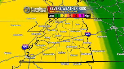
On the regional radar image above, you can see that storms have already begun to form out to our west across Oklahoma. That will be the next round of storms to move into West Tennessee, and they're expected to arrive Wednesday morning. Depending on when they get here, they could bring strong to severe thunderstorms in West Tennessee with a risk for damaging winds and large hail. An isolated tornado is possible but that chance remains low.
Again, depending on timing, things could change with those threats. If this line comes in early Wednesday morning. The atmosphere may be able to recover giving us a chance for scattered thunderstorms during Wednesday afternoon and evening resulting in another round of potentially severe weather.
Stay with the VIPIR 7 Storm Team for more updates and stay prepared!
HIGHLIGHTS
Stay with the VIPIR 7 Storm Team for more updates and stay prepared!
HIGHLIGHTS
- Isolated thunderstorms this afternoon with a more widespread line of rain and occasional thunder moving into northwest Tennessee between 6pm and 8pm
- Next wave arrives Wednesday morning with a slight risk for severe weather
- Potentially looking at another round of storms tomorrow afternoon and evening but won't know more until tonight
- Main threats are for damaging winds and large hail with each round but an isolated tornado won't be out of the realm of possibility


No comments:
Post a Comment