Monday, April 28, 2014

UPDATE: April 28th Severe Weather Outlook

As of 1:00 a.m. CDT on this Monday April 28th, the Storm Prediction Center with the National Weather Service has issued their Day 1 Convective Outlook for the area. Starting with the categories, you can see that West Tennessee is divided under the slight (yellow) risk and the moderate (red) risk.

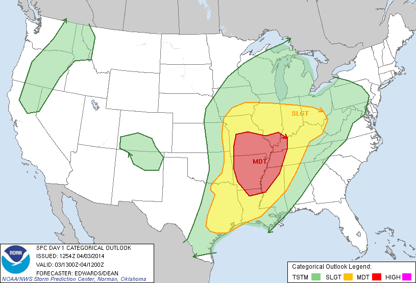
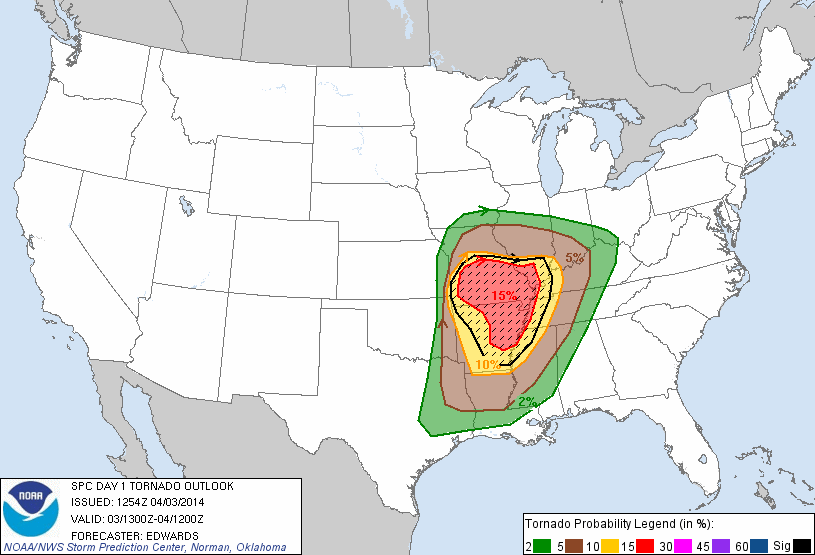
The main focus for now, will be on thunderstorms that become severe in southeast West Tennessee and southern Middle Tennessee along with parts of central and northeast Mississippi, and northwest Alabama. The Tornado Outlook shows a maximum probability of 15% (red) for the development of a tornado and 10% or greater chance for EF2 - EF5 strength tornadoes to form within 25 miles of a point in any of the hatched area.


The probabilities imply that West Tennessee is in a part of the country that is most likely to see a tornado develop tomorrow and some of those tornadoes can become strong. However, we still don't know exactly how things may develop once the atmosphere becomes worked over tomorrow morning so this is also very much something to watch for any changes. Damaging winds are also expected to be a threat but perhaps not even the main concern with thunderstorms that could become severe. 


The majority of West Tennessee will have a 30% chance to see damaging winds in excess of 60mph as thunderstorms develop during the afternoon. The northwest and western-most sections of West Tennessee are only looking at a 15% chance for damaging winds tomorrow. Finally, the hail threat appears to be the most dominant in our severe weather outlook for today.

A large portion of southeast West Tennessee and southern Middle Tennessee along with parts of central and northeast Mississippi, and northwest Alabama have a 45% chance to see hail larger than 1" today. This currently appears to be one of the main threats for the region today but don't forget about rainfall. The forecast rainfall amounts for today from 7 a.m. today (Monday) through 7 a.m. Wednesday are still forecast to total between a half to two inches added on to the heavy rainfall we had yesterday (Sunday) in the Mid-South. Flash flooding will also be a possibility  for West Tennessee once again.


A new tornado watch has just been issued for several more counties in West Tennessee including Dyer, Fayette, Haywood, Lake, Lauderdale, Shelby, Tipton, Carroll, Crockett, Gibson, Henry, Madison, Obion, and Weakley counties until 8 a.m. today. Stay tuned for more updates!


Sunday, April 27, 2014

Severe Weather Threat - April 27-29

As we start the last week of April 2014, severe weather threatens the West Tennessee region like it has been annually for several years during late April and early May. You might recall the major floods in the area from 2010, or the largest amount of tornadoes ever recorded on a single day (April 27) in 2011 affecting several states in the Mid-South. Maybe you remember that an EF-2 tornado ravaged parts of Chester county causing hundreds of thousands of dollars in damage in 2012, and last year, parts of Fayette county and other areas in West Tennessee were dealing with damage to structures, power lines, and roadways from high winds and large hail.

This year is no different. We have a possibility for severe weather across multiple days from today (Sunday) into Monday and even possibly on Tuesday. A closed upper-level low is now moving out of the Rocky Mountains into the Plains where an associated cold front, dry line, and warm front will be features in the forecast. Each one of these features could result in severe weather in West Tennessee.


I, and the other members of the VIPIR 7 Storm Team, will continue to update our social media outlets on Facebook and Twitter. We'll also continue to keep our website updated with videos and forecast discussions to the best that we can. Make sure to keep your NOAA Weather Radio on so that you have access to receive these alerts in case of power loss. We'll break into local programming on WBBJ-TV as usual in case widespread severe weather occurs or if a tornado warning has been issued for counties in our viewing area.

Stay safe and stay alert!

Thursday, April 3, 2014

Severe Weather Potential: April 3 - 4, 2014

After about 3 days of talking about the forecast for severe weather this week, today is finally here. On my walk this morning in North Jackson, the sky was already looking ominous and sunshine was peeking through the clouds.


The National Weather Service in Memphis has issued a Special Weather Statement for all of West Tennessee. You can see the text from that report here. Basically, it aligns with what we've been talking about all week.

The Storm Prediction Center with the National Weather Service has continued our moderate risk for today. As seen below, pretty much all of West Tennessee is under that moderate risk. Everyone in West Tennessee should be prepared for possible severe weather today.

Categorical Risk (West Tennessee - Mainly Moderate)
Tornado Probability (West Tennessee - 10%-15%)
Large Hail Probability (West Tennessee - 30%)
Damaging Wind Probability (West Tennessee - 45%)
It's worth noting that at this point we have our largest threats from damaging winds and large hail with another added threat for tornadoes and heavy rain that could lead to flash flooding.

At 9:42 a.m. today, thunderstorms were already making their way northeast into West Tennessee out of Memphis.


Storms have the potential to become severe as early on as during the mid afternoon and that threat will continue overnight. However, the main threat for severe weather lies with an oncoming cold front that won't be moving into West Tennessee until after midnight. Here's a look at the forecast precipitation rates for 3 a.m. Friday morning.

Rainfall rates close to and above 2"/hr in Jackson
Wind Speeds upwards of 40mph (those are sustained winds, gusts will be higher)
Stay tuned to WBBJ and to the Facebook and Twitter accounts of the VIPIR 7 Storm Team for further updates from the National Weather Service throughout the day!