Tuesday, June 11, 2013

Here Comes The Heat!


To call today hot might be an understatement. The temperatures rose above 90º throughout the majority of the Mid-South today and heat indices were above 100º. 


For those who don't know, a heat index is a number that factors in the amount of moisture in the air to describe what the temperatures feel like outside. Higher humidity makes conditions more uncomfortable, so this number is a good reflection on what we're experiencing rather than what the temperatures actually are.

In heat events, like the one we're encountering this week, its important to take necessary measures to avoid heat related illnesses. Heat is the #1 weather related killer among people today, so take these steps to heart and share them with you friends and family!


  • Slow down. Reduce, eliminate or reschedule strenuous activities until the coolest time of the day. Children, seniors and anyone with health problems should stay in the coolest available place, not necessarily indoors.
  • Dress for summer. Wear lightweight, light-colored clothing to reflect heat and sunlight.
  • Put less fuel on your inner fires. Foods, like meat and other proteins that increase metabolic heat production also increase water loss.
  • Drink plenty of water, non-alcoholic and decaffeinated fluids. Your body needs water to keep cool. Drink plenty of fluids even if you don't feel thirsty. Persons who have epilepsy or heart, kidney or liver disease, are on fluid restrictive diets or have a problem with fluid retention should consult a physician before increasing their consumption of fluids. Do not drink alcoholic beverages and limit caffeinated beverages.
  • During excessive heat periods, spend more time in air-conditioned places. Air conditioning in homes and other buildings markedly reduces danger from the heat. If you cannot afford an air conditioner, go to a library, store or other location with air conditioning for part of the day.
  • Don't get too much sun. Sunburn reduces your body's ability to dissipate heat.
  • Do not take salt tablets unless specified by a physician. 

    (From the National Weather Service - http://www.nws.noaa.gov/os/heat/index.shtml)

If you thought today was bad, just wait until tomorrow! Wednesday, our actual highs will be in the mid 90s so the heat index will exceed 100º in most of the region. The heat will let up only slightly this week after a cold front moves through the area on Thursday but highs will still be around 90º each day.

Keep cool!

Sunday, June 9, 2013

Potential Severe Weather Event: Sunday June 8th, 2013

Another chance for severe weather is going to be arriving on Sunday afternoon in West Tennessee. According to the Storm Prediction Center with the National Weather Service, northwest Tennessee is the main area concerned with the threat for severe weather. At this time it appears that damaging wind gusts and large hail will be the likeliest forms of severe weather to occur in thunderstorms that reach those limits. (Disregard "SEE TEXT" in the image below) I've gathered a few images from different forecast models to explain the synopsis for what we might expect.
The atmosphere will be pretty "juicy" as a result of a wind shift over this weekend. Now that winds are changing to be more out of the south, moisture off the Gulf will be available as the first main ingredient for storms to occur. The second will be provided by both daytime heating and a frontal boundary that's approaching the Mid-South. (Time in the image below is 7PM)
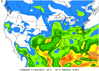
Although the cold front may not fully advance into West Tennessee until Monday, cooler air pushing under the warm air ahead of the front will enable the moisture to be lifted off the ground. As we look at the third ingredient there do seem to be some limitations. CAPE stands for Convective Available Potential Energy, and it relates to buoyancy and energy in the atmosphere. In short: more CAPE can mean stronger storms and usually we look for CAPE values over 1000 J/kg. From 1PM - 1AM the strongest levels of CAPE clearly remain west of the Tennessee River, and in some cases further west than Jackson, TN.
1PM


4PM
 

 7PM

10PM

                                        1AM - MONDAY


Finally, it's also worth discussing that the strength of the storms and the types of severe weather that we see is greatly influenced by the wind speeds on the surface and in the upper atmosphere. When these two parameters have very different values, we call that a high shear environment. In the image below, you'll notice that the forecast model is picking up on there being about 30 kts of vertical wind shear around the Mississippi River Valley at 7PM. 

Typically, this means we can expect to see a wave of heavy thunderstorms move through the area, much like one forecast model is picking up on in the image below at 7PM Sunday evening.

In summary, we'll be needing to watch the afternoon and evening times closely as a series of bands of showers and thunderstorms are expected to move through. The values and location of CAPE indicate that western-most parts of the Mid-South will be at the greatest risk including areas north of I-40 but west of Carroll and Henry counties. Storms could arrive even in the morning tomorrow, but the main severe weather event is expected to occur during the afternoon and evening on Sunday. I'll keep you apprised as to the latest updates.

Monday, June 3, 2013

The Turn, the River, and the Flop

The beginning of the month of June was anticipated to be an active time for severe weather in West Tennessee. The oncoming cold front had already done much damage to the Plains states including Oklahoma, Kansas, Missouri, and Arkansas. Tornadoes had ravaged already damaged areas and were responsible for 19 deaths including 3 storm chasers.

What we ended up encountering, here in West Tennessee was a some-what calmer scenario...

You might remember the events that took place on Thursday, May 30th in central West Tennessee. A storm cell formed in northern Mississippi and traveled north from Hardeman county, through Madison county, and exited West Tennessee through Weakley county. Although it wasn't given a severe thunderstorm warning in the Bolivar area, it ended up being warned upon entering the Jackson metropolitan area and continued that way even through western Kentucky. Winds were estimated to have gusted up to 80mph in some parts of Madison county, and trees fell over taking down power lines putting hundreds of people in the dark for several hours.


Photo courtesy: Denise Meriwether

That was the first in a series of storms that were expected to strike the Mid-South during the end of the week, but what followed was not even close to what folks farther west experienced. On Friday, we started our day out with heavy rain that added up to over an inch in many areas including Brownsville in Haywood county which actually accumulated closer to two-and-a-half inches, but the rest of the day was much drier with added sunshine.

Saturday was expected to be the day that we would have the greatest chance for severe weather. Models seemed to be coming into agreement that from 6PM to Midnight on Saturday night, we would have a chance for all forms of severe weather with the main threats being damaging winds and large hail.

The timelines I posted hardly seemed to change their trend either, which begs the question...why didn't we get the strong storms we expected?
There are a few reasons. To start, severe weather is dependent on a few main ingredients. Leaving out the technical jargon that could seem confusing I'll start from the bottom. Storms need moisture, something to lift the moisture into the atmosphere, and energy in the atmosphere to trigger the storms. In addition, the faster the winds are in the upper atmosphere, the stronger the storms tend to become. That said, moisture and lift were present, but weather forecast models expected energy to be high and it wasn't. With the lack of sufficient energy, these sub-severe storms brought winds that were estimated to have gusted up to 50mph in some parts of Madison county. They were just strong enough to push over some trees in West Tennessee that had been weakened by the storms that occurred earlier in the week.

I ended up at the McKellar-Sipes Regional Airport in Jackson Saturday early in the afternoon in search of a flat piece of land with a broad view to see the front come in. The front had arrived earlier than originally expected and along with cloud cover that prevented daytime heating, energy ended up not being significant enough to create severe weather. Observations from the event included a two hour 10º temperature drop, heavy rain, and very gusty winds. The winds at the airport gusted to 37mph.


Sunshine even started to pop out of the clouds later in the evening and it left many wondering whether or not severe weather was still imminent. It wasn't. Either way, when severe weather seems possible, it's my job to make sure you're aware of that and in the end, these experiences can help us learn more about the weather and I intend to use them that way.