Wednesday, August 30, 2017

Flash Flood and Severe Weather Potential from Harvey in West Tennessee

NOTE: This blog post is pertaining to a chance for flash flooding and severe weather that is forecast 
to occur between tonight, Wednesday, August 30th, 2017 and Friday, September 1st, 2017.


Over the next 48 hours, an historically unique amount of rainfall is expected to fall in West Tennessee. The showers will be moving in waves as rain bands associated with now Tropical Storm Harvey, soon to be come Tropical Depression Harvey, approaches the area. The forecast continues to evolve based on the new incoming model data and changes will likely be made depending on the path and speed Harvey takes through West Tennessee.


cone graphic

Harvey is now forecast to weaken to a Tropical Depression (maximum sustained winds less than 39 mph) by 7 a.m. Thursday. From there, the storm will move northeast toward West Tennessee, with the storm right overhead late Thursday night and early Friday morning. By 7 a.m. Saturday, the start of Labor Day weekend, the storm will be near Cincinatti, Ohio, far away from our area.


GOES-16 Satellite imagery shows where Harvey is now. Meteorologist Moe Shamell pointed out to me this morning that satellite is starting to show a lot of dry air on the eastern flank of the storm. Not only will this have an impact on rainfall amounts for the eastern portions of our viewing area near the Tennessee River, but it may enhance the potential for tornadoes during the day on Thursday. In the image below, moisture-filled air is shown in blue and green while dry air is shown in orange and yellow.


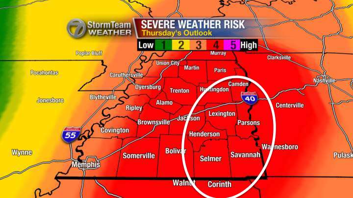
Regarding the risk for severe weather, out of the threat for tornadoes, damaging winds, or large hail, the main concern will be for a few tornadoes to develop during the day on Thursday. A Tornado Watch may be issued from the National Weather Service sometime Thursday morning. This is not uncommon with a tropical system. On the northeast flank of a cyclone, there is a very high amount of turning of the winds with height that allow for strong rotating updrafts to form brief, but usually weak, tornadoes. Keep an eye out for that Watch to be posted tomorrow.


Of course, beyond a tornado developing, the greatest and most serious concern for our weather over the next 48 hours is the threat of flash flooding. I do not want anyone to think this storm is going to be a repeat of what happened in early May of 2010 nor do I want anyone to think that exactly what happened in Texas or Louisiana is going to happen here in Tennessee, though I know that as hard as I try to dispel that idea, there will still be some who bring it up. Every storm is different, and Harvey will bring its own unique placement and intensity of rainfall.


That said, the totals could break records for daily total rainfall and 3-day total rainfall in the area. Right now, the latest computer model data is putting forecast rainfall totals all over the place in the 21 county area of West Tennessee. Some totals are less than 2" and others are between 6 and 10" for rain falling from now through Saturday morning.


A Flash Flood Watch has been issued for most of West Tennessee (Benton, Carroll, Chester, Crockett, Decatur, Dyer, Fayette, Gibson, Hardeman, Haywood, Henderson, Henry, Lauderdale, Madison, Obion, Shelby, Tipton, and Weakley counties) from 7 p.m. Wednesday through 7 p.m. Friday. 2″-6″ of rain are forecast for most of West Tennessee but with isolated totals of 6″-10″ possible in localized areas. The heaviest rain is forecast to fall from Thursday through early Friday morning.


I think the Madison County Fire Rescue squad said it best on their Facebook page this morning. "...we prepare for the worst and praying for the best."


Prepare now with your family, and have a plan in case flooding or severe weather impacts your day tomorrow. The likelihood of that happening is increasing. There are a TON of resources online freely available to tell you how to start preparations. One of those is the Red Cross.

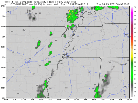
Power outages, flooded roads, school closures are all on the table tomorrow and Friday. Plan ahead! Lastly here's a simulation for what the storm may look like on radar over the next 48 hours. It begins Wednesday morning and ends Friday evening.


Summary

  • Flash flooding is the main concern. A Flash Flood Watch goes into effect Wednesday night and lasts until Friday night. Most of the area will see 2-6" fall with isolated totals of 6-10" possible. Most of the rain will fall on Thursday.
  • A few tornadoes are possible on Thursday in the Mid-South, mainly near the Tennessee River. A Tornado Watch may be issued tomorrow.
  • Rain will begin to leave the area on Friday before the Labor Day weekend.

We'll be updating our rainfall total forecast tonight, adjusting the time-frame for this event, as well as revising the risk for severe weather. Tune in to WBBJ 7 Eyewitness News tonight for the latest forecast!

Thursday, May 11, 2017

Risk for Severe Weather Tonight (5/11/17)

NOTE: This blog post is pertaining to a chance for severe weather that is forecast 
for tonight, Thursday, May 11th, 2017.

So far so good! Temperatures are in the upper 70s to lower 80s under partly to mostly clear  skies for now. We’ve had a few isolated showers this morning but nothing terribly heavy yet. The main points of discussion in this post are the risk for severe weather later today and tonight, and the chance for scattered showers and thunderstorms on Friday.

Lets talk data…

At the moment, some of the more reliable models still have considerable differences within them, so even though we’re within 24 hours of seeing thunderstorms in West Tennessee, there’s still considerable difficulty pinning down where exactly those storms will be and when.

Here’s a look at the NAM 3km at 10pm…


…and here’s a look at the HRRR at 10pm.


Both models usually perform well, but they disagree on the placement for incoming showers and thunderstorms.  To be a little more specific, some models are allowing the rain to start between 8 and 10 PM but others suggest it could start earlier between 6 and 8 PM.

All of West Tennessee is either under a marginal risk (1 out of 5) or a slight risk (2 out of 5) for severe weather. This is a relatively low risk, but one or two thunderstorms that develop in West Tennessee tonight may become severe. If any thunderstorms do become severe, then we’ll need to be on the lookout for damaging winds and large hail. The chance for a tornado is low tonight.


After this system moves in this evening, the rest of the night and day tomorrow will have scattered showers and thunderstorms into Friday afternoon.


There’s no way to know for sure if it will rain during the West Tennessee Strawberry Festival Grand Floats Parade until tomorrow morning so we’ll prepare for the worst but hope for the best.

Best case scenario: we catch a break in the showers and get through the parade rain-free. Worst case scenario: we have a thunderstorm at 10:00am. Severe weather is even more unlikely tomorrow, so I’m not expecting that. 


So to summarize: 
  • We have a chance for showers and thunderstorms tonight and tomorrow
  • Some thunderstorms could become strong or severe tonight
  • Damaging winds and large hail are possible if any thunderstorms become severe but the tornado threat is low
  • Rain will continue to come and go Friday morning and afternoon, tapering off by sunset

Friday, April 28, 2017

Scattered Thunderstorms This Afternoon and Evening

NOTE: This blog post is pertaining to a chance for severe weather that is forecast 
for today, Friday, April 28th, 2017.

Showers have already begun in northwest Tennessee but as of this morning, West Tennessee is in an area that could see severe thunderstorms develop later on today. If you saw any of my weathercasts or posts yesterday, you know that there was still some uncertainty with this forecast. Today, the area that could see these thunderstorms is still uncertain but there are a few things we've learned from the weather data this morning.

West Tennessee is split between having no risk for severe weather at all and an enhanced risk (3 out of 5) which is largely placed north of I-40. If thunderstorms develop there today, that is where they could become severe.


To help convey the uncertainty with today's forecast, let me show you some of the latest weather data.

  GIF

This computer model shows heavy showers and thunderstorms in northwest Tennessee at 4pm.


For the exact same time frame, another model shows no rain in West Tennessee at all and all of the activity north of the Tennessee-Kentucky state line.


Most of the models side with the data that shows very little rain in West Tennessee but I'm not convinced that we'll get completely out of this one unscathed. What you need to do is stay weather aware! 
Those that live near the Tennessee-Kentucky border need to be especially vigilant today. I'll post radar updates throughout the afternoon to keep you posted on which route our weather decided to take.

So to summarize:

  • Severe weather potential exists for northwest Tennessee this afternoon and evening
  • Large hail and flash flooding will be possible if thunderstorms become severe but a large portion of West Tennessee may not see any rain at all today
  • Thunderstorms will exit West Tennessee completely as they continue to move north after midnight
Tune in to WBBJ 7 Eyewitness News tonight for the latest forecast! 

Wednesday, April 26, 2017

Tonight's Risk for Severe Weather

NOTE: This blog post is pertaining to a chance for severe weather that is forecast 
for tonight, Wednesday, April 26th, 2017.

A broken line of thunderstorms is traveling across Arkansas and Missouri and is forecast to arrive in West Tennessee tonight. Those storms may arrive as soon as 7pm for parts of West Tennessee near the Mississippi River. Either way, tonight is a night to be weather aware!


Here's an animated image for what the radar could look like this afternoon and evening as the cold front moves in...

  GIF

The graphic I posted last evening on the arrival time of these thunderstorms hasn't changed much, the storms will arrive after sunset for most of West Tennessee but could come as early as between 6-8pm for areas along the Mississippi River.


The risk for severe weather has increased since yesterday's outlook with much of West Tennessee under a slight risk (2 out of 5) and some areas of southwest Tennessee under an enhanced risk (3 out of 5). The primary concern is for some thunderstorms to produce damaging winds (winds gusting over 60 miles per hour) and and large hail (hail bigger than quarters).


There's a low threat for tornadoes but an isolated tornado near the Mississippi River seems worth watching out for this evening. One of the many data products I look at when making a forecast regarding the tornado probability is the Significant Tornado Parameter. This tool gives me an idea for how likely a tornado would be within a thunderstorm. I look for values above 1 but really start to consider tornadoes a more serious threat once values are 3 or 4 and above. Those values barely reach 2 near the Mississippi River but still indicate that this a risk worth monitoring. This data shows the values will stay below 1 for most of West Tennessee tonight.

  GIF

These storms could leave a significant amount of rainfall in the area tonight as well, so flash flooding will be another concern.

So to summarize:
  • Severe weather potential for West Tennessee tonight starting at 6pm near the Mississippi River 
  • All forms of severe weather are possible though the threat for a tornado remains low
  • Thunderstorms will exit West Tennessee completely between midnight and 2am as they cross the Tennessee River
Tune in to WBBJ 7 Eyewitness News tonight for the latest forecast! I'll go through each hour of the night and cover the latest updates to our severe weather risk.

Tuesday, April 25, 2017

Multiple Rounds of Strong to Severe Thunderstorms Heading for West Tennessee

NOTE: This blog post is pertaining to a chance for severe weather that is forecast for tomorrow, Wednesday, April 26th, 2017 as well as a couple other days on the 7-day forecast.

First things first - what a beautiful sunny day it is! There isn't a cloud in the sky over Jackson right now after having a wet weekend when 4" to 6" of rain fell in parts of West Tennessee! Unfortunately, today is one of the few - if not the only completely dry day that we may have for a little while. Wednesday night, Friday night, and Sunday are all days when we could not only have heavy rain, but severe weather as well.

Let's start with tomorrow...

  GIF

A cold front will travel across Arkansas on Wednesday bringing heavy showers and thunderstorms to that area. As the cold front interacts with warm and humid air, it'll cause a risk for severe weather for most of that state. West Tennessee won't see the cold front until after sunset, so we'll be getting the leftovers of that system. 


Right now, West Tennessee is under a marginal to slight risk (1 to 2 out of 5) for severe weather Wednesday night which includes a threat for damaging winds, large hail, and an isolated tornado. The primary threat appears to be damaging winds for our area. If you have plans Wednesday evening, pay attention to updates on this forecast very closely, especially if you live in an area that is in the slight risk (yellow) area.

The Storm Prediction Center has also flagged our area for a risk for severe weather on Friday when a warm front moves through (Day 4) and on Sunday when another cold front moves through (Day 6). 


But if severe weather wasn't enough, I'm especially concerned with flash flooding happening in West Tennessee again! The GFS model is suggesting 1"-5" for West Tennessee with northwest Tennessee (namely Lake County) getting nearly 6" of rain over the next several days.


The Weather Prediction Center agrees with that suggesting a potential for excessive rainfall in West Tennessee over the next 7 days.


So, as always, stay weather aware! Keep watching our forecast for updates on what's ahead. Have a way to receive severe weather information including watches or warnings if they are issued. I'll keep you posted with another update on WBBJ 7 Eyewitness News!

Summary:
  • Severe weather possible Wednesday night, Friday night, and Sunday
  • All forms of severe weather are possible including a tornado during those days
  • Excessive rainfall is expected over the next 7 days

Thursday, March 30, 2017

Decreasing Chances for Severe Weather Today (Thursday, March 30th)

NOTE: This blog post is pertaining to a chance for severe weather that is forecast for today, Thursday, March 30th, 2017.

Yesterday, Wednesday March 29th, the Storm Prediction Center with the National Weather Service placed our area in a moderate risk for severe weather (4 out of 5) the latest update came out this morning with most of West Tennessee now in a slight risk for severe weather (2 out of 5) and I wouldn't be surprised if more of us were in a marginal risk (1 out of 5) for severe weather by the next update at 12:30pm.


SO...WHAT HAPPENED?

We look at computer models multiple times a day, 
every day, to predict how weather patterns will change over time. Part of what makes forecasting difficult is that every computer model is affected by it's own forecast. So if it has a bad forecast when the model is run at 6am, then part of that bad forecast is still included with the next run at 12pm.

Plus, we look at some models that forecast specifically for a medium range time frame (1-3 days away) versus some that look at a much shorter range (0-18 hours away). The short range models didn't get this event into view until early this morning and, in this case, were much better predictors than the medium range models.

All that said, even though the risk is lower today, it's still worth proceeding through the afternoon with caution. This graphic indicates what the radar may look like between 8 a.m. this morning and 2 a.m. Friday morning. Scattered showers and thunderstorms will be possible today, but some parts of West Tennessee may not even get any rain at all.


  GIF

The main threat within those scattered storms will be for heavy rain and lightning - typical thunderstorms, but an isolated severe thunderstorm is still possible which may produce large hail or damaging winds. The threat for tornadoes continues to look very low but it's not 0.

So to summarize:

  • Scattered thunderstorms will return to West Tennessee early between 12 p.m. and 10 p.m.
  • Large hail and damaging winds are the main threats, put your cars in a garage or carport if you can
  • An isolated tornado will still be possible but the chance for that remains low.
Stay weather aware! Have a way to receive severe weather information including a watch or warning if that is issued. I'll keep you posted with another update on WBBJ 7 Eyewitness News!

Wednesday, March 29, 2017

Risk for Severe Weather Thursday Afternoon and Evening (3/30/2017)

NOTE: This blog post is pertaining to a chance for severe weather that is forecast for tomorrow, Thursday, March 30th, 2017.

Severe weather threatens West Tennessee once again starting early Thursday morning and lasting through early Thursday evening with a brief lull at around mid-day. The western half of West Tennessee is under a slight to enhanced risk for severe weather early Thursday morning but nearly all of West Tennessee is under a moderate risk for severe weather on Thursday afternoon and evening.

Here's a look at the risk for severe weather between now and 7 a.m. Thursday...


...and this is a look at the risk for severe weather for 7 a.m. Thursday through 7 a.m. Friday though the event ends in West Tennessee sometime Thursday evening.


Damaging winds will be the primary threats if any thunderstorms are severe early Thursday morning.

Large hail and damaging winds are the primary threats with an thunderstorms that become severe Thursday afternoon and evening but 1 or 2 tornadoes will be possible as well.

This computer model shows what the radar may look like between 3 a.m. and 10 a.m. Thursday morning.

  GIF

After a brief lull in the storms around mid-day another round (a more likely event for severe weather) will move through between 1pm and 8pm. This is what the radar could look like then.

  GIF

There is NO WAY to accurately predict where a tornado will form, but the area circled in white below is where I'm most concerned for the possibility for a tornado in West Tennessee tomorrow afternoon and evening.


So to summarize:
  • Scattered thunderstorms will return to West Tennessee early between 3 a.m. and 10 a.m., a severe thunderstorm is possible but the overall risk for severe weather before 7 a.m. is a 1-2 out of 5
  • Tomorrow afternoon will be when the risk is highest for severe weather with this event
  • Timing for tomorrow is between 1 p.m. and 8 p.m.
  • Large hail and damaging winds are the main threats, put your cars in a garage or carport if you can
  • One or two tornadoes may occur tomorrow afternoon or early evening
Stay weather aware! Have a way to receive severe weather information including a watch or warning if that is issued. Keep your weather radios on tonight in case a severe thunderstorm occurs early Thursday morning.

I'll keep you posted with another update on WBBJ 7 Eyewitness News!

Monday, March 27, 2017

Risk for Severe Weather This Afternoon and Evening (3/27/2017)

NOTE: This blog post is pertaining to a chance for severe weather that is forecast for today, Monday, March 27th, 2017.

After having gusty winds and hail come through West Tennessee before sunrise this morning, the atmosphere became somewhat "stable". This usually allows severe weather to be kept at bay and keeps any strong thunderstorms from forming. This is exactly what happened to us on Saturday, when no severe weather occurred because the rain that came through in the morning sucked the energy from the atmosphere.

Unfortunately, the sun is starting to come out again, and this will likely put energy back in the atmosphere returning the risk for strong to severe thunderstorms. Here you can see the satellite showing some breaks in the clouds.

  GIF

On radar, you can see the approaching cold front. Before it arrives, scattered showers and thunderstorms will return to West Tennessee this afternoon becoming more widespread as the cold front moves into West Tennessee tonight.


Here's an idea for what the radar might look like this afternoon and evening.
  GIF

The Storm Prediction Center with the National Weather Service issued an enhanced risk for severe weather for nearly all of West Tennessee. I thought this was a bit much, and if you like thinking of the categorical risk (marginal, slight, enhanced etc.) in terms of numbers instead, I think we're looking at more of a 2-3 out of 5 instead of a solid 3.


If any thunderstorms become severe this afternoon, large hail and damaging winds will be the main threats but flash flooding and an isolated tornado will also be possible this afternoon and evening.

So to summarize:
  • Scattered thunderstorms will return to West Tennessee this afternoon and evening
  • Large hail and damaging winds are the main threats, put your cars in a garage or carport if you can
  • An isolated tornado is still possible
Stay weather aware! If you have any errands to run, keep your phone off silent so that if a watch is issued you can see that alert on your phone!

I'll keep you posted with another update on WBBJ 7 Eyewitness News!

Tuesday, January 17, 2017

18 Years Since the '99 Tornado Outbreak

NOTE: This blog post is pertaining to the F4 tornado that hit Jackson, TN on January 17, 1999.

The day began not unlike many other mild January days that Jackson has become familiar with lately. The temperature was at 54°F at 7 a.m. that Sunday morning. A strong cold front was on the way keeping skies cloudy for most of the morning and afternoon. This satellite image was taken at 8:45 in the morning.


Temperatures warmed up to 63°F that afternoon right before the Tornado Warning was issued at 6:08 p.m. for Madison county.


It was a fast moving storm! In fact, the maximum wind gust reported at the McKellar-Sipes Regional Airport that day were clocked at 88 miles per hour.

Here's the damage survey report from the National Weather Service...

"The tornado developed 3 miles west of Bemis and tracked northeast across the southern part of the city of Jackson to 3 miles northwest of Beech Bluff. A shopping center suffered severe damage while a nearby funeral home was demolished except for the interior rooms. More than 200 homes were obliterated or heavily damaged while 300 other homes sustained lesser damage. The building housing the school buses for the county was destroyed and 55 school buses were damaged. A high-school baseball stadium was destroyed and the football stadium was damaged. 6 people were killed with 106 people being injured from the tornado. $10,000,000."


While this was well before my time in Jackson, TN I know many long-time residents of the Hub City remember that day 18 years ago very well and Jackson wasn't the only place to have a tornado that night. Parts of Crockett and Haywood counties were hit as well. What do you remember?

Monday, January 9, 2017

Finally Back Above Freezing!

NOTE: This blog post is pertaining to the below freezing temperatures we had from January 5th to 9th.

Temperatures in Jackson dropped to the freezing mark at 12:30 p.m. on Thursday afternoon. Today we finally returned to a temperature above 32°F at 9:35 a.m. this morning!

That makes it 5,585 consecutive minutes since we were at or below freezing! (3 days, 21 hours, and 5 minutes)

The last time we had a temperature stay at or below 32°F for that long was from February 14th to 20th in 2015. It was much longer of course - a total of 
8,807 consecutive minutes at or below freezing!

When we're below freezing for extended periods of time, we can sometimes have an unusual weather phenomenon called a "cryoseism", better known as a "frost quake", occur. This happens well-below freezing temperatures cause a freeze in water underground. When this water freezes it expands and sometimes cracks when stress in this ice builds up. Some people have likened the sound of this deep underground ice cracking to gunfire, so don't be alarmed if you hear it this week or the next time we have temperatures this cold.


Enjoy the warm up this week, and keep that umbrella handy for the rain tomorrow!

Friday, January 6, 2017

Snow Day 1/6/2017

NOTE: This blog post is pertaining to the snow that fell today, Friday, January 6th, 2017.

Well here we are Friday morning and many parts of West Tennessee are ending up with more snow than we had forecast this morning or last night! We'll probably end up with 2"-4" by 10am in parts of Jackson which is an inch or two more than the dusting to 2" we had forecast on Good Morning West Tennessee. Areas north of I-40 that were only expected to get a dusting are getting closer to an inch or more. That's also more than the National Weather Service or any TV outlet had forecast so we're all in the same boat. After all, we were all looking at the same data!

Let me explain...

West Tennessee usually has a liquid equivalent ratio of 1" of water equaling 10" of snow. Today, the drier air allowed that ratio to go to 1" of water equaling 15" of snow! That means if this were rain, we would have 0.15" of rain on the ground - not a lot. When the air get drier it becomes much more challenging to forecast snowfall accurately. Forecasting rainfall to the hundredth of an inch is virtually impossible.

I'm sorry if you were planning on sending the kids to school today and made a decision based on our forecast that didn't go well. Hopefully everyone can enjoy a three day weekend and stay inside today.

We'll have a full wrap up of today's snowfall totals coming up on WBBJ!