Thursday, March 30, 2017

Decreasing Chances for Severe Weather Today (Thursday, March 30th)

NOTE: This blog post is pertaining to a chance for severe weather that is forecast for today, Thursday, March 30th, 2017.

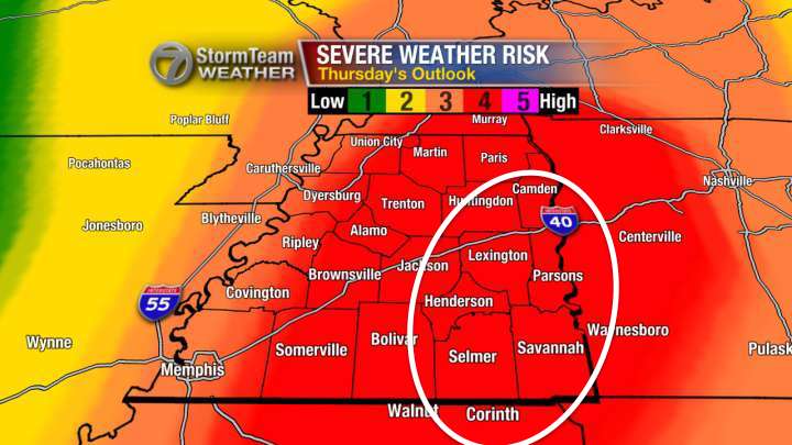
Yesterday, Wednesday March 29th, the Storm Prediction Center with the National Weather Service placed our area in a moderate risk for severe weather (4 out of 5) the latest update came out this morning with most of West Tennessee now in a slight risk for severe weather (2 out of 5) and I wouldn't be surprised if more of us were in a marginal risk (1 out of 5) for severe weather by the next update at 12:30pm.


SO...WHAT HAPPENED?

We look at computer models multiple times a day, 
every day, to predict how weather patterns will change over time. Part of what makes forecasting difficult is that every computer model is affected by it's own forecast. So if it has a bad forecast when the model is run at 6am, then part of that bad forecast is still included with the next run at 12pm.

Plus, we look at some models that forecast specifically for a medium range time frame (1-3 days away) versus some that look at a much shorter range (0-18 hours away). The short range models didn't get this event into view until early this morning and, in this case, were much better predictors than the medium range models.

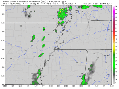
All that said, even though the risk is lower today, it's still worth proceeding through the afternoon with caution. This graphic indicates what the radar may look like between 8 a.m. this morning and 2 a.m. Friday morning. Scattered showers and thunderstorms will be possible today, but some parts of West Tennessee may not even get any rain at all.


  GIF

The main threat within those scattered storms will be for heavy rain and lightning - typical thunderstorms, but an isolated severe thunderstorm is still possible which may produce large hail or damaging winds. The threat for tornadoes continues to look very low but it's not 0.

So to summarize:

  • Scattered thunderstorms will return to West Tennessee early between 12 p.m. and 10 p.m.
  • Large hail and damaging winds are the main threats, put your cars in a garage or carport if you can
  • An isolated tornado will still be possible but the chance for that remains low.
Stay weather aware! Have a way to receive severe weather information including a watch or warning if that is issued. I'll keep you posted with another update on WBBJ 7 Eyewitness News!

Wednesday, March 29, 2017

Risk for Severe Weather Thursday Afternoon and Evening (3/30/2017)

NOTE: This blog post is pertaining to a chance for severe weather that is forecast for tomorrow, Thursday, March 30th, 2017.

Severe weather threatens West Tennessee once again starting early Thursday morning and lasting through early Thursday evening with a brief lull at around mid-day. The western half of West Tennessee is under a slight to enhanced risk for severe weather early Thursday morning but nearly all of West Tennessee is under a moderate risk for severe weather on Thursday afternoon and evening.

Here's a look at the risk for severe weather between now and 7 a.m. Thursday...


...and this is a look at the risk for severe weather for 7 a.m. Thursday through 7 a.m. Friday though the event ends in West Tennessee sometime Thursday evening.


Damaging winds will be the primary threats if any thunderstorms are severe early Thursday morning.

Large hail and damaging winds are the primary threats with an thunderstorms that become severe Thursday afternoon and evening but 1 or 2 tornadoes will be possible as well.

This computer model shows what the radar may look like between 3 a.m. and 10 a.m. Thursday morning.

  GIF

After a brief lull in the storms around mid-day another round (a more likely event for severe weather) will move through between 1pm and 8pm. This is what the radar could look like then.

  GIF

There is NO WAY to accurately predict where a tornado will form, but the area circled in white below is where I'm most concerned for the possibility for a tornado in West Tennessee tomorrow afternoon and evening.


So to summarize:
  • Scattered thunderstorms will return to West Tennessee early between 3 a.m. and 10 a.m., a severe thunderstorm is possible but the overall risk for severe weather before 7 a.m. is a 1-2 out of 5
  • Tomorrow afternoon will be when the risk is highest for severe weather with this event
  • Timing for tomorrow is between 1 p.m. and 8 p.m.
  • Large hail and damaging winds are the main threats, put your cars in a garage or carport if you can
  • One or two tornadoes may occur tomorrow afternoon or early evening
Stay weather aware! Have a way to receive severe weather information including a watch or warning if that is issued. Keep your weather radios on tonight in case a severe thunderstorm occurs early Thursday morning.

I'll keep you posted with another update on WBBJ 7 Eyewitness News!

Monday, March 27, 2017

Risk for Severe Weather This Afternoon and Evening (3/27/2017)

NOTE: This blog post is pertaining to a chance for severe weather that is forecast for today, Monday, March 27th, 2017.

After having gusty winds and hail come through West Tennessee before sunrise this morning, the atmosphere became somewhat "stable". This usually allows severe weather to be kept at bay and keeps any strong thunderstorms from forming. This is exactly what happened to us on Saturday, when no severe weather occurred because the rain that came through in the morning sucked the energy from the atmosphere.

Unfortunately, the sun is starting to come out again, and this will likely put energy back in the atmosphere returning the risk for strong to severe thunderstorms. Here you can see the satellite showing some breaks in the clouds.

  GIF

On radar, you can see the approaching cold front. Before it arrives, scattered showers and thunderstorms will return to West Tennessee this afternoon becoming more widespread as the cold front moves into West Tennessee tonight.


Here's an idea for what the radar might look like this afternoon and evening.
  GIF

The Storm Prediction Center with the National Weather Service issued an enhanced risk for severe weather for nearly all of West Tennessee. I thought this was a bit much, and if you like thinking of the categorical risk (marginal, slight, enhanced etc.) in terms of numbers instead, I think we're looking at more of a 2-3 out of 5 instead of a solid 3.


If any thunderstorms become severe this afternoon, large hail and damaging winds will be the main threats but flash flooding and an isolated tornado will also be possible this afternoon and evening.

So to summarize:
  • Scattered thunderstorms will return to West Tennessee this afternoon and evening
  • Large hail and damaging winds are the main threats, put your cars in a garage or carport if you can
  • An isolated tornado is still possible
Stay weather aware! If you have any errands to run, keep your phone off silent so that if a watch is issued you can see that alert on your phone!

I'll keep you posted with another update on WBBJ 7 Eyewitness News!