NOTE: This blog post is pertaining to a chance for severe weather that is forecast for tomorrow, Thursday, March 30th, 2017.
Severe weather threatens West Tennessee once again starting early Thursday morning and lasting through early Thursday evening with a brief lull at around mid-day. The western half of West Tennessee is under a slight to enhanced risk for severe weather early Thursday morning but nearly all of West Tennessee is under a moderate risk for severe weather on Thursday afternoon and evening.
Here's a look at the risk for severe weather between now and 7 a.m. Thursday...

...and this is a look at the risk for severe weather for 7 a.m. Thursday through 7 a.m. Friday though the event ends in West Tennessee sometime Thursday evening.

Damaging winds will be the primary threats if any thunderstorms are severe early Thursday morning.
Large hail and damaging winds are the primary threats with an thunderstorms that become severe Thursday afternoon and evening but 1 or 2 tornadoes will be possible as well.
This computer model shows what the radar may look like between 3 a.m. and 10 a.m. Thursday morning.

After a brief lull in the storms around mid-day another round (a more likely event for severe weather) will move through between 1pm and 8pm. This is what the radar could look like then.

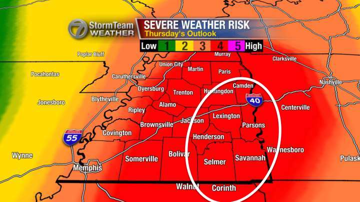
There is NO WAY to accurately predict where a tornado will form, but the area circled in white below is where I'm most concerned for the possibility for a tornado in West Tennessee tomorrow afternoon and evening.
So to summarize:
- Scattered thunderstorms will return to West Tennessee early between 3 a.m. and 10 a.m., a severe thunderstorm is possible but the overall risk for severe weather before 7 a.m. is a 1-2 out of 5
- Tomorrow afternoon will be when the risk is highest for severe weather with this event
- Timing for tomorrow is between 1 p.m. and 8 p.m.
- Large hail and damaging winds are the main threats, put your cars in a garage or carport if you can
- One or two tornadoes may occur tomorrow afternoon or early evening
Stay weather aware! Have a way to receive severe weather information including a watch or warning if that is issued. Keep your weather radios on tonight in case a severe thunderstorm occurs early Thursday morning.
I'll keep you posted with another update on WBBJ 7 Eyewitness News!
I'll keep you posted with another update on WBBJ 7 Eyewitness News!
No comments:
Post a Comment