Tuesday, November 17, 2015

Flood and Damaging Wind Threat Tonight

NOTE: This blog post is pertaining to a flooding and damaging wind threat forecast for tonight, the night of Tuesday, November 17, 2015.

An area of low pressure is forcing colder air through the Central and Southern Plains today creating a wide band of showers and thunderstorms that stretch from the Great Lakes to the Gulf Coast. Windy and wet weather are forecast for all of West Tennessee tonight and will last through Wednesday morning. This was a look at the VIPIR 7 Dopplar Radar at 2:17 this afternoon.


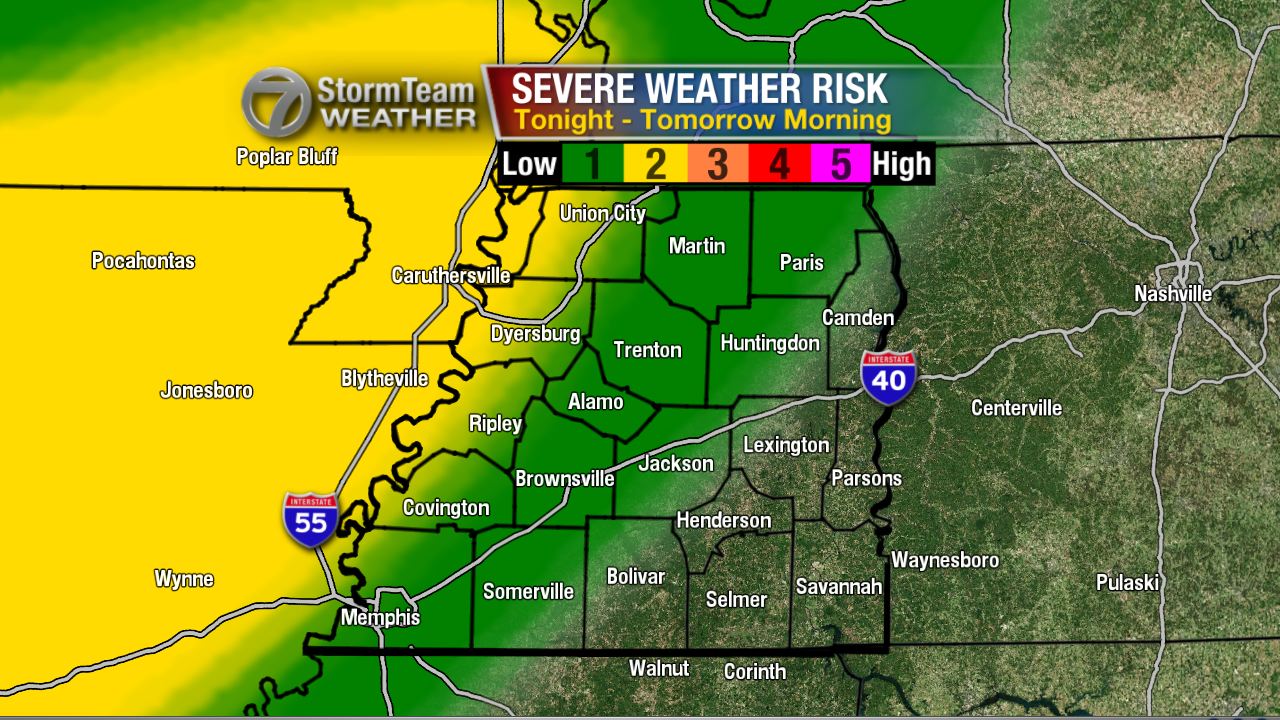
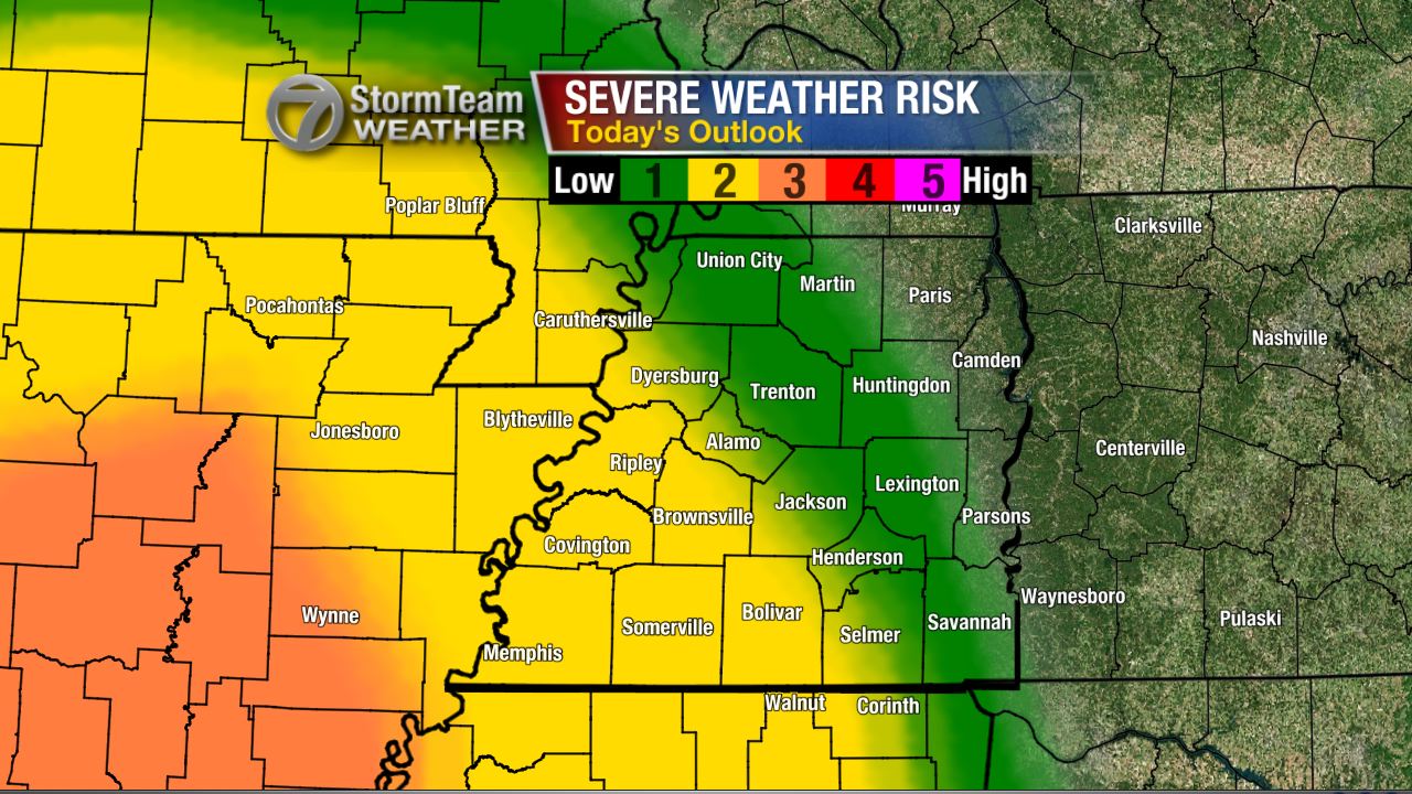
There's a slight risk (2 out of 5 chance) for thunderstorms to become severe in southwest Tennessee tonight posing a threat for localized damaging winds. There's also a low threat for tornadoes which seems to be an event more likely to take shape farther to the south and west of West Tennessee.


The band of heavy rain currently pushing through Louisiana, Arkansas, and Missouri will arrive in the western-most counties of West Tennessee between 9pm and midnight tonight. This band of rain will be moving through the area for a duration of 12 hours, so the slow progression of heavy rain will create a risk for flash flooding - especially in low lying areas with poor drainage.


The winds will be strongest before the rain arrives. A Wind Advisory is in effect for all of West Tennessee tonight into tomorrow morning. Wind gusts will generally be between 30 and 40 mph but could be as high as 50 mph in some spots outside of any thunderstorms.


When the rain arrives, the winds may actually calm down some, but any thunderstorms that become severe could result in wind gusts over 60 mph. The area most likely to see that occur will be in the counties of West Tennessee that border Mississippi and areas south of the TN-MS border.


When the rain is finally over Wednesday morning, we'll be left with an additional 1"-3" of rain on the ground added to the rain most people saw last night. Keep an eye out for flooded roadways on the morning commute, and always remember to find a safer route to your destination if you happen come upon one.


Be safe and keep an eye out for more updates from the VIPIR 7 Storm Team.

Wednesday, November 11, 2015

Severe Weather Risk Tonight

NOTE: This blog post is pertaining to a severe weather threat from the night of Wednesday, November 11, 2015.

Even yesterday, there still seemed to be a decent chance for thunderstorms to become severe near the Mississippi River tonight. The Storm Prediction Center had a slight risk (colored in yellow) for severe weather in western West Tennessee.


Now, that threat is even lower with all of West Tennessee looking at a 1 out of 5 chance or a marginal risk for storms to become severe tonight, but I would contend that that threat is even lower. 


At 9pm tonight (Wednesday), is when I expect storms will be their strongest in West Tennessee which is when a broken line of thunderstorms will be approaching the Mississippi River. After that, storms will continue to become weaker. Most of West Tennessee will have a chance for rain but thunderstorms will NOT be widespread.


If one or two storms DO become severe, the main threat will be with damaging winds. There's very little instability with these storms but there are very strong winds in the upper atmosphere. If any of these winds mix down to the surface, we could have one or two events of downed trees or power lines.


Otherwise, winds will be at their strongest just before the heaviest rain enters West Tennessee. We might see a few power outages as a result of 20 mph winds which VIPIRCast shows over Crockett county and bordering areas. 


Still, this event doesn't look like it'll amount to much more than what we had last Thursday night - a little wind and rain with occasional thunder. I'll be tracking the storms coming up on WBBJ 7 Eyewitness News!

Thursday, November 5, 2015

UPDATE: Severe Weather Potential

NOTE: This blog post is pertaining to a severe weather threat from the night of November 5, 2015 into the early morning of Friday, November 6, 2015

We're still tracking a line of strong thunderstorms bringing heavy rain and gusty winds to northwest Arkansas. Right now, there's very little going on with this line that qualifies as severe weather as it pertains to what will impact West Tennessee.


There are severe weather watches currently in effect for locations well to our west including across parts of Missouri and Arkansas. As of 7:46 p.m., no watches have been issued in or near West Tennessee. If they are issued, we'll let you know.


Overall, the threat for severe weather appears even lower than before. As of right now, we're looking at a low risk for any thunderstorms to become severe. If one or two of these storms does exhibit severe characteristics, the main thing to watch out for is still damaging winds. Otherwise it looks like we'll just be dealing with some rain, thunder, and maybe a little wind at times after midnight through Friday morning.


Make sure to tune into WBBJ for the very latest.Be safe, and have a good night!

Severe Weather Potential Overnight

NOTE: This blog post is pertaining to a severe weather threat from the night of November 5, 2015 into the early morning of Friday, November 6, 2015

Above, is the image of what the regional radar was showing at 2:54pm on Friday, November 5th. The area of rain identified by the #1 is rain that is moving northeast into Southeast Missouri - this is not what we're tracking for our risk for severe weather tonight. Instead, we're watching object #2 which is where severe thunderstorm warnings and tornado warnings are currently in place in Oklahoma. #2 is the squall line that will be moving into West Tennessee tonight to bring our chance for bad storms.


The severe weather risk has changed a little from yesterday. The slight risk (2 out of 5 chance) has shifted slightly east indicating a greater chance for severe storms in Union City, Tiptonville, Ridgely, Dyersburg, Ripley, and Covington. The marginal risk (1 out of 5 chance) remains for areas to the east where we may see a strong thunderstorm or two but the risk is low for severe thunderstorms.

Now since I know you're wondering, the answer is yes - there is a small chance for a tornado tonight, especially in the northwest corner of West Tennessee. Though the risk is low, I'll be here all night watching the event in case we see anything that could lead to these thunderstorms producing a tornado.


It's a little more likely that instead of a tornado, we have to deal with severe thunderstorms producing damaging winds. Once again, especially in northwest Tennessee.


 To sum it up, here's a look at the threats for severe weather that could potentially occur tonight and early tomorrow morning. The main focus is on damaging winds and flash flooding. Frequent lightning is also possible in the strong thunderstorms.


On Friday, the threat for strong thunderstorms may redevelop Friday afternoon in areas that get the tail end of tonight's event.


Unfortunately, this may coincide with high school playoff football games. Below, is a map of where home games will be played tomorrow in and around West Tennessee. The kids can play in the rain, but not in lightning. I'm especially concerned with the risk for lightning in Adamsville, Savannah, Waynesboro, and Scotts Hill tomorrow night. Keep an eye on the forecast for future updates!


It's been a long time since we've had a risk for severe weather in West Tennessee. Now, would be a good time to take a deep breath and relax for a second, because this is a relatively low risk for severe weather. I'll be watching this all night so don't panic. Download our app too! That way you can program alerts into your phone if a severe weather is coming to your house.

I'll have more tonight!

Tuesday, October 13, 2015

One Year Since the Last Tornado Warning

Not that anyone is complaining, but with only 2 weak tornadoes forming in West Tennessee in May, it's been a relatively quiet year for severe weather. The Severe Thunderstorm Warning issued for Henry and Benton counties Monday evening was the first time a warning has been issued in West Tennessee since August 15th. We haven't had a tornado warning issued anywhere in West Tennessee since October 13th - of last year.

This "tornado drought" isn't unprecedented as the past 3 years have had less than 4 tornadoes occur each year in West Tennessee. In the last decade, the largest tornado outbreaks have happened in 2010, 2008, and 2006 when at least 10 tornadoes occurred during each of those years in this area.


However, if you look at it in terms of how many tornado warnings were issued each year over the last decade, 2015 really stands out! There have been 0 tornado warnings issued in West Tennessee in 2015 and that only comes close to 2007 when 5 warnings were issued throughout the entire year.


According to Zachary Maye with the National Weather Service in Memphis, the longest West Tennessee went without a tornado warning was from June 9, 1986 to December 15, 1987 which adds up to 554 days. That number still far surpasses the 365 days we're at now.

West Tennessee is going to be dealing with the effects of El Niño this winter which occurs when temperatures of the water in the Pacific Ocean are warmer than average. The weather in West Tennessee is typically not severe during El 
Niño but as we transition out of El Niño into La Niña, things often become more active. We might see an increase in severe weather next year and in 2017. 

Overall, it doesn't look like we'll be seeing severe weather again in the immediate future but the months of November and December typically see a bump in tornado frequency so it's always best to be prepared just in case!


For now, enjoy the sunshine and the beautiful Fall weekend ahead...


Friday, June 26, 2015

Severe Weather Risk for Friday June, 26

8:39 a.m. Friday, June 26

I wish there was a way for this forecast to change, I really do! Nobody wants to move to a new house in the rain. Unfortunately, since yesterday, it looks as though the risk for severe weather has become more enhanced over West Tennessee today. I'm not going to sugar-coat it, I'll just give you the bullet points for what to expect:


  • Scattered showers and thunderstorms will begin forming in West Tennessee from the late morning into the afternoon.
  • If you have outdoor activities planned today, understand that there is a likely chance for frequent lightning in some of these storms. Remember to head indoors at the first sign of lightning or thunder!
  • The risk for severe weather today is a 3 for most of West Tennessee (enhanced risk) and with any storms that become strong or severe today, the biggest threat for severe weather will be from damaging winds and large hail. Tying down some of those loose outdoor items you might have at your home would be a good idea.
  • The probability for an isolated tornado is low, but if one does happen to form, it would be likelier to do so in the northern half of West Tennessee.
  • Showers and thunderstorms will continue moving through the area until Saturday morning, at which point we'll transition into drier and cooler weather for the weekend.

ONE MORE THING: If you live in Madison county and rely on NOAA Weather Radio for weather alerts, the Jackson, TN broadcast is having technical difficulties. Workers are on the scene making repairs, but it is possible that it might not be ready in time before storms start forming today. MAKE SURE YOU HAVE A WAY TO GET WEATHER ALERTS! You can see alerts crawling across the bottom of your screen on WBBJ, or even download our app for or free on Apple (http://bit.ly/1fUs7vD) and Android (http://bit.ly/1g3VrjL) devices!

Be safe and stay weather aware!

Friday, April 24, 2015

Severe Weather Risk for Saturday, April 25th

There is a slight risk for severe weather in West Tennessee Saturday morning and early afternoon.


As a warm front moves into West Tennessee overnight, showers and thunderstorms will continue with the best chance for any thunder and lightning near the Tennessee-Mississippi border. The back edge of the bulk of showers and thunderstorms will likely move east of the Tennessee River after 7 a.m. CDT.

However, we may still see a few scattered storms in eastern counties of West Tennessee (Henry, Carroll, Benton, Henderson, Decatur, Chester, McNairy, and Hardin counties) during the hours after sunrise. Activity will be moving northeast with strong southwesterly winds. By the time the atmosphere gets more energy, most of the rain, and the ingredients to cause the storms will have moved north and east. Right now, it appears unlikely that West Tennessee will see severe weather.


If any storms become severe they could contain damaging straight-line winds and large hail. Heavy rainfall in these thunderstorms could also lead to flash flooding.


This forecast is all about timing, and the way the models have panned this out, it just doesn't seem like it's in the cards for this to be a severe weather event for West Tennessee. Even after all the rain is said and done, tomorrow will still be a windy day. Winds could gust over 30 miles per hour.


Summary

  • Showers and thunderstorms overnight (t'storms possible near southwest TN)
  • Showers become more isolated after sunrise
  • A few stray storms are possible late morning early afternoon
  • The chance for severe weather is low
  • Windy weather coming in the afternoon


Sunday, April 19, 2015

Severe Weather Risk for the Night of Sunday, April 19th

3:30 p.m. - 

Rain showers and a few thunderstorms are moving northeast across West Tennessee. There are a few pockets of isolated heavy rain but these storms are NOT associated with the main threat for severe weather today which will arrive tonight. In fact, you can expect a nice sunset soon as clouds are continuing to disappear in the southwest Tennessee sky right now.

There is a slight to enhanced risk for severe weather in West Tennessee. 


It will be dry to end the daylight hours but between 8pm and 9pm, a line of thunderstorms will be moving over the Mississippi River heading east into West Tennessee. It should be in the vicinity of Jackson around 10 or 11pm.
Most of West Tennessee will just get some gusty winds and heavy rain, but a few of these storms could be or become severe as they cross the Mississippi River. The main threat from any storms that become severe will be from damaging straight-line winds and large hail. There's the outside chance for a tornado to occur in the Mid-South though the probability is low. 

In any event, make sure your weather radios are on and that you have some way of getting severe weather information. If you're on social media (and chances are that that's how you found this blog) then follow the VIPIR 7 Storm Team on FacebookTwitter, and Instagram for updates. The Twitter page is the most reliable source for real-time weather update information.

Quick Notes

  • Expect a nice sunset
  • Line of thunderstorms will move through West Tennessee from 8p-1a
  • Most of West Tennessee will at least get gusty wind and rain
  • A few severe thunderstorms are possible with the threat of straight-line winds (+60mph) and large hail
  • Tornadoes are possible but unlikely
Stay weather aware!

Thursday, April 9, 2015

Severe Weather Potential for the Night of Thursday, April 9th

Good morning!

An area of low pressure in the Central Plains is moving northeast toward the Upper Midwest today. Trailing behind that is a cold front that could bring severe weather to West Tennessee later tonight.

Concerning the daytime, at any point during the afternoon there is a 30%-40% chance for a scattered thunderstorm in West Tennessee which will have the potential to become strong or severe but that threat will be localized. The cold front won't come into West Tennessee until between late tonight and early Friday morning. When it does, this is what the risk for severe weather looks like in our area.


The western two-thirds of the West Tennessee region will have a 2-3 (medium) risk for severe weather to occur. This is where we'll probably be tracking thunderstorms capable of damaging winds and large hail.

As you can see below, the damaging wind and hail threat will be the main concern today - especially when the front arrives later tonight. If any tornadoes form in tonight's thunderstorms they would be more likely to occur near the Mississippi River than compared to the Tennessee River.

As the line moves east, the threat for severe weather will mainly turn into a damaging wind threat as the thunderstorms form a line, but I don't want to discount the risk for flash flooding. Some of the thunderstorms ahead of the the front could produce rainfall rates of up to 2" per hour, so localized flash flooding is still going to be something that we'll have to look out for.

Just to reiterate, the main line of storms won't come until later tonight, though a scattered storm will be possible this afternoon. Here's a look at the timing for that main line.

The Big Takeaway:
This is NOT an event to panic about. I also don't think that we should expect a widespread outbreak of severe thunderstorms. Most areas will probably just see thunderstorms with some heavy rain, lightning and some gusty winds. A few locations could get some hail and damaging winds. Be prepared for the worst and hope for the best!

In any event, the VIPIR 7 Storm Team is committed to updating you with later developments throughout the day on FacebookTwitter, and Instagram. Like or follow our pages by clicking on those links!

Plus, don't forget to download the WBBJ 7 Eyewitness News app on Apple and Android devices. There, you can set up weather alerts for your area and use an interactive radar to track the storms throughout the day.

I'll keep you posted!

Friday, April 3, 2015

Good Friday Severe Weather Risk

At 11:31 p.m. CDT on April 2nd, 2015, a cold front approaching the Mid-South was already igniting severe weather in the Central plains. This same cold front could also cause severe weather to occur in parts of West Tennessee very early Friday morning, Friday afternoon, and through early Friday evening.
 

As the front approaches northwest Tennessee it will gradually slow down but ongoing thunderstorms to our north could become severe with a risk of large hail, damaging winds and heavy rainfall that could lead to flash flooding. In fact, much of western Kentucky and southeast Missouri is under a Flood Watch.


 There are also Severe Thunderstorm and Tornado Watches issued to our north and northwest.


The main thing to consider is that when the front approaches West Tennessee thunderstorms will develop. So, by that thinking, the chance for thunderstorms will increase from northwest to southeast in West Tennessee as we go into Good Friday morning, afternoon, and early evening.

However, the atmosphere will be "capped" initially. This simply means that severe thunderstorms will have a hard time developing at first. By the afternoon, that cap will diminish and thunderstorms will be more likely to form along the cold front as it moves through West Tennessee.

The timing for the main threat...


 and the risk...

 
are important considerations in making your plans throughout the day, today.

 
Also consider that we're expecting the main impact from these storms to come from large hail, damaging winds, and flash flooding should they become severe. An isolated tornado cannot be ruled out but there is a low probability for that right now.

After sunset most, if not all, of the thunderstorms will be out of West Tennessee and we can enjoy a quiet and cooler Easter weekend.

 
Myself and the rest of the VIPIR 7 Storm Team will keep you posted throughout the day! Here's how to contact us...


Wednesday, March 4, 2015

UPDATE: Winter Weather Expected March 4th - 5th

A few aspects of this forecast will be adjusted, but for the most part, things seem relatively similar to how they did last night. This is what the radar lapse looked like during the late morning hours of the day. It's from our interactive radar and it's a great way to track where the rain sleet and snow is relative to your house!


Temperatures dropped quite a bit last night after they were at 63°F at 12:53 am in Jackson. We're already in the 30s in northwest Tennessee but still had 60s in southeast counties of West Tennessee near Savannah around 11am.


This is the latest timeline for how the precip will change, but this is for the specific spot of Jackson. Points northwest of Jackson will see the change from rain to ice sooner and points southeast will see it later, just like we expected last night.


The green line above represents rain, red represents freezing rain, purple represents sleet, and blue represents snow. So the timing remains unchanged for Jackson for the most part. The only thing that has had a change is the increase in chance for precipitation overnight. In other words, the freezing rain, sleet, and snow will be heavier when it falls. This, of course, will have an impact on how much we get.

More on probabilities...


The above graphic shows where the chance for a quarter inch of ice to accumulate is located. Those areas colored in blue have a 40%-60% for that to happen - somewhat likely. This is what we had forecast last night, but snowfall could be higher than I mentioned yesterday.


This graphic shows the probability of where in West Tennessee 4" of snow could fall. Red/orange areas have an 80%-90% chance for that - northwest Tennessee. Along I-40, the chance is there but it drops off to 40%-60% over Jackson, so not as likely but still possible. It's unlikely that southeast West Tennessee gets 4".


Finally, for Jackson, the latest output is still showing a very wide range of forecast snow accumulation by noon Thursday. It's best to not focus on the highest potential but instead to watch the average value which is between 3"-4" of snow for Jackson.

I'll be increasing forecast snow & sleet totals across West Tennessee slightly. Leaning toward 2"-4" of snow and sleet for Jackson now with a quarter inch 
or less of freezing rain. I'll post the maps later today. Further updates will be made to our website.

Good luck and stay safe!

Winter Weather Expected March 4th - 5th

The fact that it's only one year (almost to the day) that separates West Tennessee between two dangerous ice storms is odd enough, but it's only 17 days until Spring arrives and before the week is over parts of West Tennessee, including Jackson, may set new record low temperatures for the month of March. Winter isn't going down without a fight!

First off, temperatures...At 12:23 a.m. when I started writing this blog, this is what it looked like across West Tennessee.


In about 24 hours, these numbers may be 30 degrees cooler in some spots, thanks to a cold front that will come along with showers and breezy winds overnight.

Rain will be off and on throughout the morning on Wednesday, but with rain showers hitting certain spots over and over again, flooding could be a problem. This will be especially true in low lying areas that may also have poor drainage. A Flash Flood Watch is in effect for northwest Tennessee until noon Wednesday.

Speaking of weather alerts, all of West Tennessee will be under a Winter Storm Warning from today until noon Thursday.


A warning, in this case, simply means that this winter weather event is imminent and very likely to occur. So you're probably wondering when it will really start going and how much snow and ice we'll get.

Rain will change over to freezing rain during the afternoon and evening hours today (Wednesday)...


This change will start early in the afternoon in northwest Tennessee and continue to take place later on at points southeast throughout the rest of the day on Wednesday. Parts of Hardin and McNairy county may not see the phase change occur until a few hours before midnight. In Jackson, this change will probably take place around 5pm give or take an hour. At that point, and at the times shown above, it's recommended that you avoid going on the roads since travel will become increasingly difficult. Eventually, that freezing rain will change to sleet and then to snow making travel dangerous with roads becoming icy. 

Here's how much sleet and snow accumulation we could get along with freezing rain...


You've probably looked at other sources and might be wondering why ours are so "low". Well, it seems to me like the warmer weather will hang around slightly longer, and so this will lead to lower amounts of snow and sleet.


BUT, the impacts are still there. In this case, it's best not to get caught up on amounts and just make sure you're prepared for these potential impacts...


With a quarter inch of ice on tree branches on power lines and winds gusting over 30mph, spotty power outages are bound to happen. With icy road conditions, accidents are bound to happen Wednesday night and Thursday morning. With dangerous conditions, school closures are bound to happen. These will be the things to watch for and prepare for.

I'll keep you posted with another update coming out later this morning.