NOTE: This blog post is pertaining to a severe weather threat from the night of November 5, 2015 into the early morning of Friday, November 6, 2015

Above, is the image of what the regional radar was showing at 2:54pm on Friday, November 5th. The area of rain identified by the #1 is rain that is moving northeast into Southeast Missouri - this is not what we're tracking for our risk for severe weather tonight. Instead, we're watching object #2 which is where severe thunderstorm warnings and tornado warnings are currently in place in Oklahoma. #2 is the squall line that will be moving into West Tennessee tonight to bring our chance for bad storms.
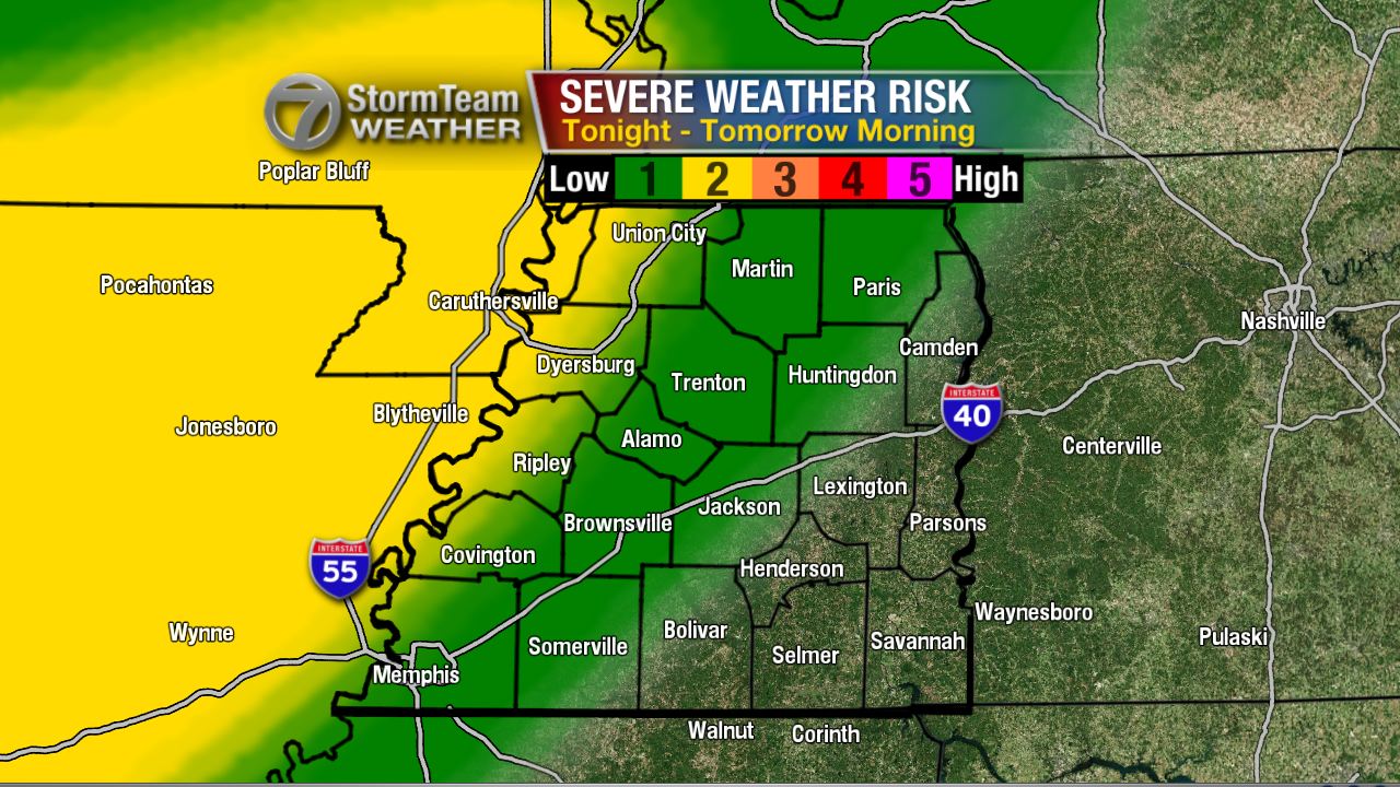
The severe weather risk has changed a little from yesterday. The slight risk (2 out of 5 chance) has shifted slightly east indicating a greater chance for severe storms in Union City, Tiptonville, Ridgely, Dyersburg, Ripley, and Covington. The marginal risk (1 out of 5 chance) remains for areas to the east where we may see a strong thunderstorm or two but the risk is low for severe thunderstorms.
Now since I know you're wondering, the answer is yes - there is a small chance for a tornado tonight, especially in the northwest corner of West Tennessee. Though the risk is low, I'll be here all night watching the event in case we see anything that could lead to these thunderstorms producing a tornado.

It's a little more likely that instead of a tornado, we have to deal with severe thunderstorms producing damaging winds. Once again, especially in northwest Tennessee.

To sum it up, here's a look at the threats for severe weather that could potentially occur tonight and early tomorrow morning. The main focus is on damaging winds and flash flooding. Frequent lightning is also possible in the strong thunderstorms.

On Friday, the threat for strong thunderstorms may redevelop Friday afternoon in areas that get the tail end of tonight's event.

Unfortunately, this may coincide with high school playoff football games. Below, is a map of where home games will be played tomorrow in and around West Tennessee. The kids can play in the rain, but not in lightning. I'm especially concerned with the risk for lightning in Adamsville, Savannah, Waynesboro, and Scotts Hill tomorrow night. Keep an eye on the forecast for future updates!

It's been a long time since we've had a risk for severe weather in West Tennessee. Now, would be a good time to take a deep breath and relax for a second, because this is a relatively low risk for severe weather. I'll be watching this all night so don't panic. Download our app too! That way you can program alerts into your phone if a severe weather is coming to your house.
I'll have more tonight!
No comments:
Post a Comment