Wednesday, February 25, 2015

Morning Update for Snow Chances Tonight (Wednesday, February 25th)

We're still dry in West Tennessee so far, but I can't say the same for our neighbors to the south across parts of Arkansas and Mississippi. This is a look at public reports through an interactive weather app called mPING* of precipitation types over the last 6 hours...


A lot of locations across Mississippi have reported sleet or rain recently with most of the precip having stayed farther south of a line from Tupelo, MS to Clarksdale, MS. Temperatures have been fickle, flirting with freezing in those locations, while most of West Tennessee, including Jackson, just got to 31° at 10:00 a.m. this morning. Temperatures will continue to rise in West Tennessee but in locations where snow, sleet, or freezing rain is being reported the temperature will remain steady or drop.


Our latest snowfall forecast from last night still had a dusting to 2" in southeastern-most parts of West Tennessee toward McNairy and Hardin counties. However, with the recent model trends showing the system staying farther south and hardly even making it over the Tennessee-Mississippi line, we could be looking at only a dusting in some areas. If the precip begins as rain, it'll be pretty hard for the snow to stick, making for a big bust in this forecast.


In other words, now it's time to wait and see! Send us your reports and pictures if you can! Precip will approach the southern counties of West Tennessee during the late afternoon and continue moving northeast from there on out through the evening.

*If you would like to use mPING to send in your reports of what type of precip you're seeing, you can - it's easy! All you need is a smart phone or tablet. For Apple devices the app can be downloaded on iTunes and for Android devices the app can be downloaded on Google Play. If you'd like to view the reports from others for yourself, you can do so on the app or on their website.

Tuesday, February 24, 2015

Another Round of Winter Weather Coming Wednesday


A Winter Storm Warning has been issued for Alcorn and Tishomingo counties in northeast Mississippi, and for McNairy and Hardin counties in southwest Tennessee from 6 a.m. Wednesday to midnight Wednesday night.

A Winter Weather Advisory has been issued for Tipton, Haywood, Madison, Chester, Henderson, Decatur, Shelby, Fayette, and Hardeman counties in West Tennessee from 6 a.m. Wednesday to midnight Wednesday night.

The clouds took a while to clear this morning but finally by the afternoon, we were looking at sunshine again. Temperatures warmed up into the mid and upper 30s across most locations but cold weather will return in earnest to West Tennessee after winter weather wallops West Tennessee once more on Wednesday.

Tonight, skies will become cloudy at times later on in the night with light winds out of the southwest. Temperatures will drop to the low and mid 20s by Wednesday morning. Wednesday will start out dry but as skies become mostly cloudy after noon, snow showers will start moving into southern portions of the Mid-South with temperatures warming up to the upper 30s and low 40s.

Snow showers will begin moving into southwest Tennessee just before sunset on Wednesday night. Afterwards light to moderate snow could be seen anywhere in West Tennessee, but will be likeliest south of I-40 where significant accumulations could occur. Counties that are under a Winter Storm Warning (McNairy and Hardin) could see 2"-3" of snow while other areas south of I-40 could get as much as 1"-2" including parts of Bolivar, Henderson, and Parsons which are in counties under a Winter Weather Advisory. Along and north of the interstate, as much as a dusting to 1" of snow will be possible.

Later on in the week, Thursday and Friday will be bitterly cold as a region of cold air moves into the Mid-South. The weekend will begin a warming trend as temperatures warm into the mid and upper 40s under partly cloudy skies on Saturday. March will begin on Sunday with even warmer weather but will also come along with rain showers from a cold front that will move into the area on Sunday night.

Stay tuned to the VIPIR 7 Storm Team for the latest on the forecast!

Sunday, February 22, 2015

Another Chance for Winter Weather Tonight (Sunday, February 22nd)

The 'cabin fever' continues! Areas of southwest Tennessee may once again get a chance for snow, sleet, and freezing rain tonight.

Starting with the radar, you can see an area of mostly rain (green and yellow) with ice (purple) and snow (blue/gray) moving northeast toward the Memphis area.


Temperatures at 4:15pm were still above freezing across most of West Tennessee with 40s still being observed near Savannah.


However as temperatures inevitably cool down overnight, there will be a change over from rain to freezing rain and sleet and possibly snow across the area of southwest Tennessee later tonight. Once again, I-40 seems to be a good boundary for describing where the "heaviest" precip will fall tonight. Areas to the south of the interstate could see a half inch or less of snow and a quarter inch or less of freezing rain overnight while areas farther north should deal with lighter precip amounts or none at all. 

The National Weather Service in Memphis has issued Winter Weather Advisories for Shelby, Fayette, Hardeman, McNairy, and Hardin counties from 9pm tonight (Sunday) through 9am Monday. In these locations, snow and ice will make driving difficult tomorrow morning.


The wintry mix will start pushing into the southwest corner of the state between 6 and 9pm with the bulk of the precip falling between 9pm and midnight. Make sure to check the road conditions outside before you decide to travel!

Saturday, February 14, 2015

UPDATE: Winter Weather Potential for President's Day

A Winter Storm Watch is in effect for all of the Mid-South from 6pm Sunday through 6pm Monday. This means that we're still expecting significant winter weather to cause travel problems primarily on President's Day.


Hopefully you've enjoyed the nice warm weather today - much weather than we anticipated!

For any Valentine’s plans tonight, expect the wind to continue to be gusty as colder air moves into the region behind the oncoming cold front.
We might start with a break of sunshine in the morning but the forecast gusty winds and temperatures in the teens have prompted a wind chill advisory over the area. Wind chills below zero will be possible in the morning, especially in northwest Tennessee.


Precipitation won't start to move into the area until after dark on Sunday and will continue overnight into Monday morning. It will likely start as an ice/snow mix over most of the area before changing to all snow. Freezing rain will be possible in northern Mississippi and extreme southwest Tennessee where accumulating ice could cause tree limbs to fall on to power lines resulting in spotty outages in those areas. However, most of West Tennessee will get mostly snow with up to 5" or a little more accumulating by lunchtime on Monday. Temperatures will struggle to get above freezing each day from Sunday through Wednesday as cold air settles in.


Stay tuned for more updates from the VIPIR 7 Storm Team!

Winter Weather Potential from Sunday - President's Day

Over the past few days, the forecast has changed quite a bit. So here's where we stand now...

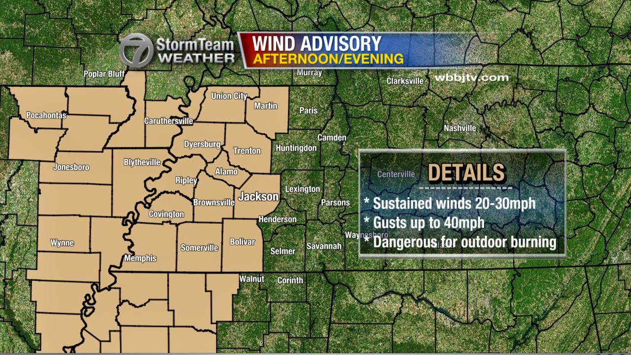
The forecast for today kept getting warmer and now it looks like we could have a good shot at 50°F around lunchtime. However, the warm weather will last very briefly before it gets cold and windy! Sustained wind speeds will peak between 20 and 30 miles per hour this afternoon with gusts up to 40 at times. It's mainly the western half of West Tennessee that will be dealing with the strongest winds which will begin out of the west and shift to be out of the north after a cold front comes through.


That cold front is going to bring dangerously cold air to the region. Sunday morning, wind chills could be in the single digits with readings a few degrees below zero possible too.


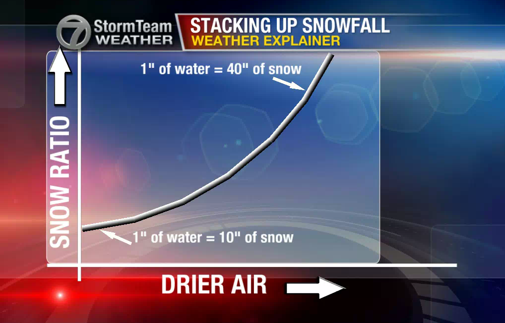
This cold air isn't just going to come in feeling frigid, but will also be very dry and THAT is one of the issues that's going to make this forecast so difficult. With drier air, the ratio between inches of liquid equivalent and inches of snow increases exponentially. In West Tennessee, we typically have a 10:1 ratio, which means that for every inch of water that falls, we get 10 inches of snow. However, this time, the snow ratio could be higher than that since the incoming air will be so dry.


Let's look at that with some actual numbers...

This is our in house computer model's projections for snowfall totals based on a 10:1 (normal) ratio for snow that starts Sunday night and lasts into Monday morning. Most of the values are between a trace and 3". (By the way, this is just a model projection and it has its flaws)


By comparison, this is what the same model's projection looks like based on a 15:1 (drier air) ratio for the same time frame. It's nearly an inch different in some areas! Watching the air move in from the north behind the incoming cold front is going to be key with forecasting snowfall totals.


Right now, we're sticking with a trace to 3" across the area - going with a snowfall ratio that's just a little bit higher than normal. It's worth mentioning at this point, that the reason why we're going lower in southernmost parts of West Tennessee, is because there's a potential for sleet to be mixed in with the snow in those areas. Most parts of West Tennessee should see only snow, but ice could mix in with the snow at first in southwest Tennessee.

It's possible that later today or tomorrow, the National Weather Service will issue winter weather alerts for West Tennessee so make sure you're familiar with the terms below and what they mean.

Winter storm watches are issued well in advance of an event when conditions are possible. On the other hand, advisories and warnings are when the event is imminent - soon to occur or already occurring.

Incidentally, the next week as a whole will be very cold. We may even get another chance for snow on Thursday! There's still some uncertainty in the forecast though, so make sure to watch Good Morning West Tennessee with meteorologist Eddie Holmes for the latest. We'll keep you updated throughout the weekend!

Wednesday, February 4, 2015

Update: Light Snow Expected Tonight (Wednesday, February 4th, 2015)

There doesn't appear to be a need to change our forecast from last night. 


If you're trying to plan out Thursday morning take this into consideration - remember the snow we got on the night of Friday January 23rd? It was only a dusting. That's about how much we're expecting tonight, if not just a little bit more.

Potential impacts:


  • With ground temperatures still above freezing, it's likely that any snow that melts on contact will refreeze as temperatures drop. Thursday morning, area bridges may have ice on them and so you'll want to watch those areas closely. Give yourself extra distance between your car and the car in front of you.
  • Your car doors are probably going to be difficult to open if your car isn't in a garage. Give yourself some extra time to take care of that tomorrow morning.
  • It's going to be cold. Winds will be blowing out of the north between 10 and 20 miles per hour making it feel like it's in the single digits. Wear lots of layers!
We'll have more on this on WBBJ 7 Eyewitness News later tonight!

Tuesday, February 3, 2015

Potential Snowfall by Thursday, February 5, 2015

Tomorrow, February 4th is what we might consider the "mid-point" of Winter with half the season over and another half still to go. The first day of Spring in 2015 is on March 20th and for those wishing for warmer weather, it couldn't come a minute too soon!

Regarding the potential for snowfall in West Tennessee from Wednesday night into Thursday morning, don't expect a big storm. There's currently only a 10%-20% chance for 1" of snow to accumulate anywhere in West Tennessee. Those numbers aren't impressive so we shouldn't worry about getting a lot of snow with this system. Still, with a lack of snowfall removal resources in rural areas of West Tennessee, there's a potential for hazardous travel Thursday morning.


Our in-house computer model is showing a chance for at least a trace amount of snowfall as far south as into parts of northern Mississippi. However, with all precipitation expected to be falling very lightly, whether its snow or rain, I'm a bit skeptical that we'll see accumulation that far to the south. Considering there's still some uncertainty as to how warm/cold the atmosphere will be when precipitation starts, I think that most, if not all, of the sticking snow will be north of the Tennessee-Mississippi border.

Based on that computer model, these are the projected snowfall totals as of 6:30 p.m. Tuesday February 3rd, 2015 by noon on Thursday -


Currently, I'm leaning on the side of this snowfall resulting in a dusting across most of West Tennessee. Heavier amounts (basically a heavy dusting) will be possible in areas north of I-40.


In the worst-case scenario where the cold air gets here sooner than currently expected, we could see higher snowfall totals.

In that event, counties in northwest Tennessee especially those that border western Kentucky and southeast Missouri, could get 1"-2" of snow. Most of West Tennessee, including extreme northern portions of Mississippi, would get at least a trace of snowfall if that situation pans out.


We'll be monitoring this one closely, with another update coming out Wednesday morning.