Thursday, January 21, 2016

Major Winter Storm Expected Friday (1/22/2016)

NOTE: This blog post is pertaining to a winter storm forecast for Friday, January 22, 2016.

Weather Update - 4:30 p.m. Thursday

West Tennessee will undergo impacts from a major winter storm over the next 24 hours. A Winter Storm Warning has been issued for every one of the 21 counties in West Tennessee from Thursday night to Friday night. This means that significant snow and ice are imminent and it's important that you make your preparations before the event begins late tonight and early Friday morning!

 
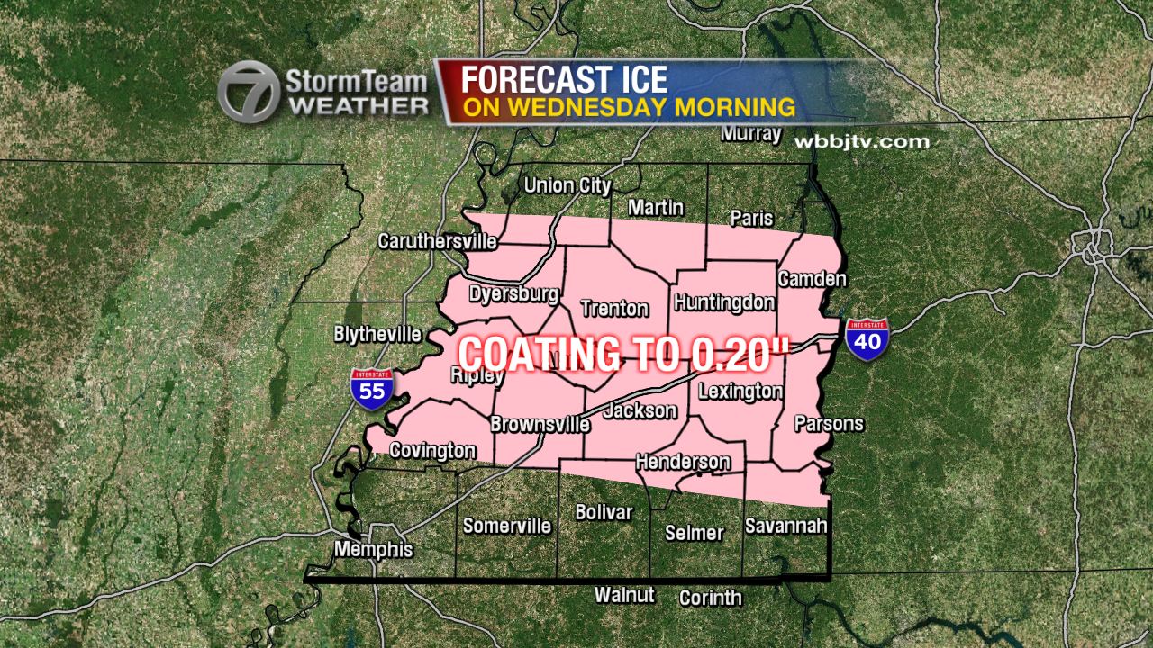
Tonight, rain showers will continue to spread into West Tennessee from south to north. With cold air in place over northwest Tennessee, this will result in a chance for freezing rain and sleet overnight in counties north of Interstate-40. A tenth of an inch of ice will be possible in these areas and road conditions will gradually deteriorate. Along and south of Interstate-40, the main precipitation type will be rain, and a cold rain at that. In southwest Tennessee, especially near the Tennessee-Mississippi border, it will be possible that a rumble of thunder is heard overnight.


Tomorrow morning, the rain and ice will change over to snow between 5am and 9am. This will take place earlier in areas north of I-40 and later in areas south of I-40. All snow, is expected from 9am through lunch time. Some of that snow will be heavy at times resulting in dangerous travel conditions. Wind could gust between 30 and 40 miles per hour. Any accumulating ice and snow on tree branches, could result in power outages across West Tennessee due to these strong winds.


Snow will taper off Friday night into early Saturday morning, but road conditions will take time to improve since temperatures will only barely get above freezing on Saturday. Black ice will be possible Saturday night in locations that see any melting take place.


Stay with the VIPIR 7 Storm Team for the very latest updates to this forecast.

Tom Meiners
Storm Team 7 Chief Meteorologist, CBM
Twitter - @WBBJ7TomMeiners
Facebook - facebook.com/WBBJ.tom.meiners
Email - tmeiners@wbbjtv.com


Wednesday, January 20, 2016

Significant Snowfall Possible Friday (1/22/2016)

NOTE: This blog post is pertaining to a winter storm forecast for Friday, January 22, 2016.

Weather Update - 4:20 p.m. Wednesday

A WINTER STORM WATCH has been issued for all of West Tennessee from midnight Thursday night (12 a.m. Friday) until 6 p.m. Friday evening. A Winter Storm watch means there is a potential for significant snow, sleet, or ice accumulations that may impact travel.

Temperatures have barely reached the freezing mark again in West Tennessee. Jackson's high temperature for the day, so far, has been at 34°F. Cloudy skies will stick around and the lack of warm weather will keep some of the snow and ice in place that fell across parts of northwest Tennessee. Some school closures or delays will be possible there on Thursday. Rain will begin moving into West Tennessee throughout the day on Thursday with a change over to snow taking place early Friday morning.

Tonight, temperatures will drop to the upper 20s and low 30s under cloudy skies and light northeast winds. We'll remain rain-free until scattered showers start Thursday morning advancing from south to north throughout the morning and afternoon. Some of these showers may begin initially as freezing rain but change over to rain as relatively warmer air moves in.


Sometime around sunrise on Friday morning, rain will change over to snow. The time this takes place for your area will depend on where in West Tennessee you are. It looks right now like areas near the Mississippi River will see the change before sunrise, but areas near the Tennessee River may not see the change until the later hours of the morning. By lunchtime, there should only be snow falling in West Tennessee. Snow showers will become more scattered and lighter by the later hours of the afternoon and early evening.


Accumulation could be significant on Friday. Pay attention to updates to forecast snowfall as this forecast is subject to change. With temperatures staying below freezing for the start of the weekend, we may not see significant melting take place until Sunday.

KEY POINTS:

1. The forecast could still change to show higher amounts or lower amounts of snow forecast for the area. This is a very difficult forecast with a lot of unknowns still.
2. Be prepared for school closures on Friday.
3. Expect the snow to stick around into the weekend.
4. The forecast amount of snow could still chance, yes I'm repeating this so you hear it :)


Stay tuned to the latest forecast from the VIPIR 7 Storm Team for the latest updates!

Tom Meiners
Storm Team 7 Chief Meteorologist, CBM
Twitter - @WBBJ7TomMeiners
Facebook - facebook.com/WBBJ.tom.meiners
Email - tmeiners@wbbjtv.com

Tuesday, January 19, 2016

Snow and Ice Early Wednesday

A Winter Weather Advisory has been issued for all 21 counties of West Tennessee through Wednesday morning. Snow, sleet, and freezing rain are expected to begin moving in the region before sunrise tomorrow before we transition to rain and a wintry mix by lunchtime. Travel could be hazardous in spots and though it won't be impossible, caution is still strongly advised if you have to go out tomorrow. It's possible that some schools may close or delay their opening due to the weather.


Tonight, skies will remain cloudy with temperatures hovering just under freezing even at the coldest point of the night. After midnight, a snow and sleet mix will begin moving into northwest Tennessee with the wintry mix taking over much of the area by 6am. This is going to be a difficult forecast because we may only see rain with some freezing rain mixed in near the Tennessee-Mississippi border, but near the Tennessee-Kentucky border, we may see only snow fall. Every form of winter precipitation is going to be possible in between.


All things considered, travel could be difficult tomorrow, but not impossible. After noon, above freezing temperatures will lead to any accumulations of snow and ice to start melting. Temperatures will reach the mid to upper 30s and low 40s by the afternoon. We'll get a brief break from the wintry mix before rain returns on Thursday afternoon and evening before changing to all snow on Friday morning. It's possible that we once again have accumulation, but this time mainly from snow, ice does not look as likely this time.
 
Stay with the VIPIR 7 Storm Team for future updates to this forecast!