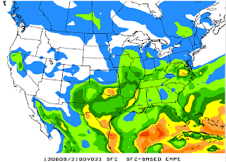
The atmosphere will be pretty "juicy" as a result of a wind shift over this weekend. Now that winds are changing to be more out of the south, moisture off the Gulf will be available as the first main ingredient for storms to occur. The second will be provided by both daytime heating and a frontal boundary that's approaching the Mid-South. (Time in the image below is 7PM)
Although the cold front may not fully advance into West Tennessee until Monday, cooler air pushing under the warm air ahead of the front will enable the moisture to be lifted off the ground. As we look at the third ingredient there do seem to be some limitations. CAPE stands for Convective Available Potential Energy, and it relates to buoyancy and energy in the atmosphere. In short: more CAPE can mean stronger storms and usually we look for CAPE values over 1000 J/kg. From 1PM - 1AM the strongest levels of CAPE clearly remain west of the Tennessee River, and in some cases further west than Jackson, TN.
1PM
4PM
7PM
10PM
1AM - MONDAY
Finally, it's also worth discussing that the strength of the storms and the types of severe weather that we see is greatly influenced by the wind speeds on the surface and in the upper atmosphere. When these two parameters have very different values, we call that a high shear environment. In the image below, you'll notice that the forecast model is picking up on there being about 30 kts of vertical wind shear around the Mississippi River Valley at 7PM.
Typically, this means we can expect to see a wave of heavy thunderstorms move through the area, much like one forecast model is picking up on in the image below at 7PM Sunday evening.
In summary, we'll be needing to watch the afternoon and evening times closely as a series of bands of showers and thunderstorms are expected to move through. The values and location of CAPE indicate that western-most parts of the Mid-South will be at the greatest risk including areas north of I-40 but west of Carroll and Henry counties. Storms could arrive even in the morning tomorrow, but the main severe weather event is expected to occur during the afternoon and evening on Sunday. I'll keep you apprised as to the latest updates.


No comments:
Post a Comment