Regional radar currently shows us the line of storms that moved through the Plains last night, and that it survived the trip across Arkansas now approaching West Tennessee.

A closer look reveals even a few isolated storms in northwest Tennessee early this morning. So far, as of 7:44 a.m. none of these storms or the storms to our west are going severe but we'll be monitoring as that is a small possibility.

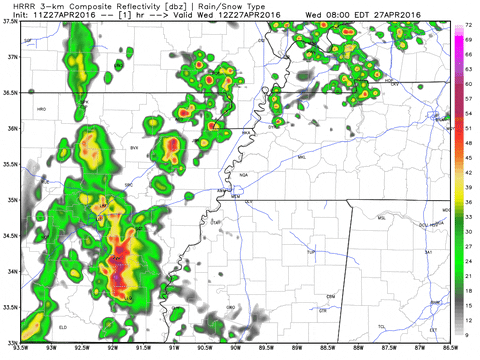
However, the latest model data, which you can see below, suggests that as those storms continue to move northeast into West Tennessee, that they weaken and gradually dissipate across our area. This would be round 2 of the storms with a 3rd round of scattered activity during the afternoon and drier weather after sunset tonight.
The rain we get from this next wave could help stabilize the atmosphere more for the afternoon preventing us from seeing severe weather, but that's impossible to set in stone. There are still a lot of uncertainties, but overall, our risk for severe weather remains relatively low - a 2 out of 5.

If any thunderstorms DO become severe today, the main threats will be with severe thunderstorms that could produce large hail and damaging winds. The threat for an isolated tornado continues to look very low.

HIGHLIGHTS
- Rain moving into West Tennessee now may keep our severe weather risk to a minimum today
- Still under a slight risk (2 out of 5) for severe weather across the area
- Main concern still lies with large hail and damaging winds if any scattered thunderstorms develop during the afternoon
No comments:
Post a Comment