A lot are asking about the timeline, so lets start with that...

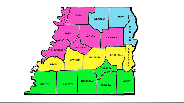
Now lets look at what we're talking about...

BLUE
You're looking at snow first, but eventually changing over to sleet and freezing rain with rain by Sunday night. 0"-2" of snow forecast for your area before it melts Sunday evening.
PINK
You're looking at snow briefly on Sunday morning but it changes over to ice during the later hours of the morning and afternoon. 0.2" or less of accumulating ice is possible in your area before it melts Sunday evening when precip changes to all rain.
Yellow
You're looking at ice Sunday morning with a trace amount of accumulation. Precip will change over to all rain Sunday afternoon and evening.
Green
This COULD briefly be ice but will mostly be a rain event in your area. Wouldn't be surprised if there was heavy rain at times. 1"-2" of rain will be possible. Isolated thunder perhaps as well.
Travel impacts will be minimal unless you're in a county that's in PINK or BLUE. If that's the case, there could be icy conditions on Sunday morning and afternoon before warmer air moves in during the evening.
REMINDER: This should just be seen as a guide. Weather NEVER follows map boundaries so if you live near a county border, you could get close to both of the conditions expected for your nearby counties.
No comments:
Post a Comment