Sunday, February 14, 2016

Sunday Morning Forecast Update for Today, February 14th

NOTE: This blog post is pertaining to a chance for winter weather that is forecast for Sunday, February 14th.


Over the next 8-10 hours, parts of West Tennessee could be dealing with icy conditions north of I-40. However, many of us may not even start to see any precipitation until tonight. A Winter Weather Advisory is in effect until 6pm tonight for northwest Tennessee.

This morning at 5:00 a.m., radar showed isolated snow showers and a few areas of sleet in northwest Tennessee near the Tennessee-Kentucky border. These showers are moving east-southeast at 30-40 mph.


The latest short term data has been fairly consistent that areas north of I-40 will see scattered snow and ice through the morning before taking a break around lunch-time and then resuming as just rain later this afternoon.

At 6am, models are suggesting very limited coverage of shower activity in northwest Tennessee. At that time it's a mixture of snow and ice.


By 9am, activity starts becoming more widespread north of I-40 with a mixture of freezing rain (red), sleet (pink), and some snow (blue).


At 12pm noon, some of the ice changes over to rain (green). Notice that a LOT of areas south of I-40 may still not have yet seen ANY rain fall at this point.


By 3pm, all precipitation falling in West Tennessee will have changed to just rain and continues to fall predominantly over northwest Tennessee.


At 6pm, showers are starting to move more throughout West Tennessee starting to spread farther south. All precip is still rain.


Areas like Savannah and Selmer, may possibly only just start to see rain by late tonight around midnight.


So for some of you, it may take a while before you start to see anything come down in your area - especially if you live south of I-40. Otherwise, scattered snow and ice showers will be possible through the morning before changing to all rain early this afternoon.
  • Snow and ice falling in northwest Tennessee now (5:00am) but showers will be isolated in nature at first
  • Icy road conditions will be possible where snow, sleet, and freezing rain fall today since temperatures are cold enough for it to stick on contact
  • All precip may fall as rain from the early afternoon on through the rest of the event that could last into Monday morning.
  • Less than 2" of snow is expected near the Tennessee-Kentucky border. Most of West Tennessee won't get any snow at all!
  • Light accumulations of freezing rain and sleet will be possible north of I-40 but individual results may vary.
Keep an eye on our Facebook and Twitter accounts today for the latest updates! In the meantime, here's a useful way to check road conditions reported by TDOT --> CLICK ME

Saturday, February 13, 2016

Quick Afternoon Forecast Update for Sunday, February 14th

NOTE: This blog post is pertaining to a chance for winter weather that is forecast for Sunday, February 14th. Revisions to this forecast may be necessary so keep an eye out for updates. If you're short on time, head to the bottom for the quick version.

A lot are asking about the timeline, so lets start with that...


Now lets look at what we're talking about...


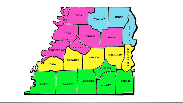
BLUE
You're looking at snow first, but eventually changing over to sleet and freezing rain with rain by Sunday night. 0"-2" of snow forecast for your area before it melts Sunday evening.

PINK

You're looking at snow briefly on Sunday morning but it changes over to ice during the later hours of the morning and afternoon. 0.2" or less of accumulating ice is possible in your area before it melts Sunday evening when precip changes to all rain.

Yellow

You're looking at ice Sunday morning with a trace amount of accumulation. Precip will change over to all rain Sunday afternoon and evening.

Green
This COULD briefly be ice but will mostly be a rain event in your area. Wouldn't be surprised if there was heavy rain at times. 1"-2" of rain will be possible. Isolated thunder perhaps as well.


Travel impacts will be minimal unless you're in a county that's in PINK or BLUE. If that's the case, there could be icy conditions on Sunday morning and afternoon before warmer air moves in during the evening.

REMINDER: This should just be seen as a guide. Weather NEVER follows map boundaries so if you live near a county border, you could get close to both of the conditions expected for your nearby counties.

Wintry Mix Possible Sunday, February 14th

NOTE: This blog post is pertaining to a chance for winter weather that is forecast for Sunday, February 14th. Revisions to this forecast may be necessary so keep an eye out for updates. If you're short on time, head to the bottom for the quick version.

There's very little change so far in the forecast, but the fact that it shows similarities to yesterday, means my confidence is only increasing. If there's anything you need to take away from this forecast, it's that this is likely going to be mostly a ICE and RAIN event, there will only be a little snow which not everyone will see.

VIPIRCast brings the rain, ice, and snow mixture into West Tennessee by Sunday morning, so this could start as soon as church services are getting underway on Sunday.


While snow is possible, it's likeliest to fall in northwest Tennessee near the Kentucky-Tennessee border. I wouldn't be surprised if we saw a quick inch or two fall near Union City, Martin, Paris, or Camden Sunday morning and afternoon. 
Ultimately, that's where our best chance for 1" of snow to fall is. Northern Henry county is especially looking at the best chance for snow accumulation. Don't be surprised if there's a trace amount on the ground in Huntingdon, Trenton, or Dyersburg or even northern Decatur and Henderson counties.


Ultimately, our best chance for ice to fall will be in northwest Tennessee (areas north of I-40), the guidance on this has shown that that's where our best chance for travel impacts will be but not all the models agree.


Some models are still suggesting ice over a good portion of northwest Tennessee - especially areas north of I-40. Amounts are still VERY uncertain at this time but we'll keep an eye on that.


In the meantime, here's the quick version of this forecast:

  • This will mostly be ice-to-rain event with areas north of I-40 likeliest to see sleet and freezing rain
  • Snow will be possible in northwest Tennessee too, but the likeliest area to see any accumulation is parts of West Tennessee near the Tennessee-Kentucky state border
  • Eventually all precipitation will change over to rain on Sunday night
  • Travel in parts of West Tennessee north of I-40 will be at the greatest risk for travel impacts on Sunday. If you were planning on driving through that area, check the road conditions before you leave to drive tomorrow
I'll post another update Sunday morning. In the meantime, watch WBBJ 7 Eyewitness News at 8 with Meteorologist Eddie Holmes and at 6 and 10 with Meteorologist Chelsea Ambriz!

Tuesday, February 2, 2016

Severe Weather Possible Today: Morning Update

NOTE: This blog post is pertaining to a risk for severe weather that is forecast for today - Tuesday, February 2, 2016. Revisions to this forecast may be necessary so keep an eye out for updates. If you're short on time, head to the bottom for the quick version.

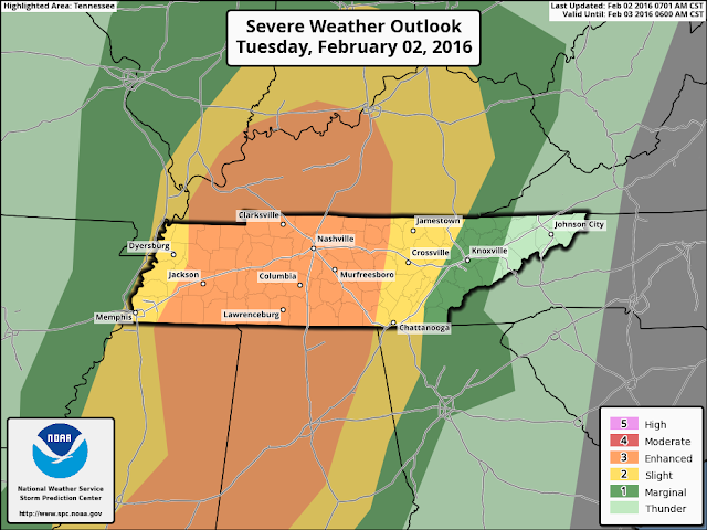
The threat for severe weather in West Tennessee today, February 2nd, 2016 remains at a medium level. The latest forecast from the Storm Prediction Center with the National Weather Service shows a "slight" to "enhanced" risk for severe weather which is basically a level 2 to 3 out of 5.


While yesterday, it appeared that the main timeframe for storms would be between the early afternoon and evening (2pm to 8pm), that timeframe appears to be changing. West Tennessee will see scattered showers ahead of the cold front, but the main threat may not arrive until the later afternoon (4 or 5pm) and not leave until the later evening (10 or 11pm). This would keep most of the storms from arriving until after school dismissal.


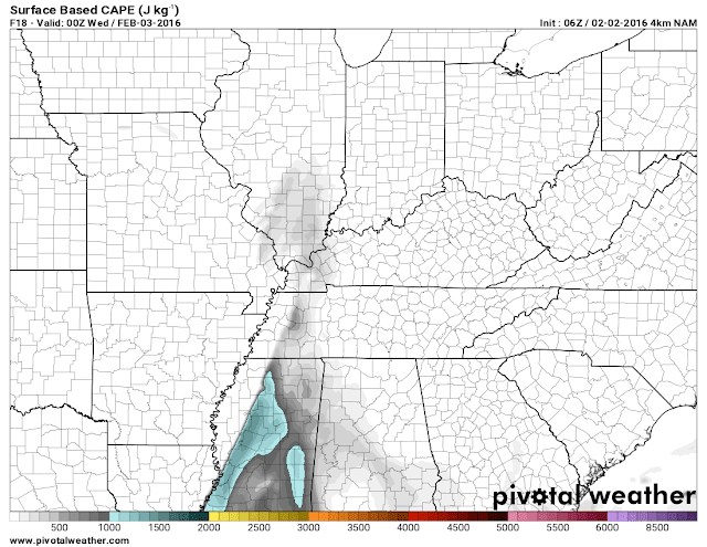
The latest look at how much energy is available is less than it looked yesterday which is normally a good thing, but in the wintertime, the Mid-South typically doesn't need a TON of energy to get things started. I'm trying to stay optimistic with this new information, but threat is still worth taking precautions for.


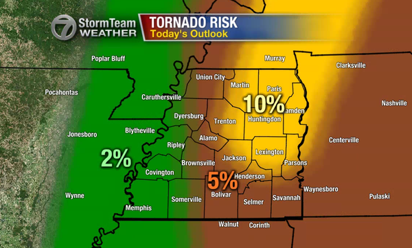
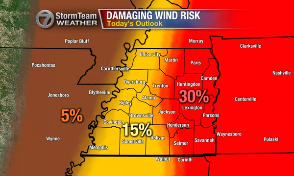
The latest forecast risk for tornadoes in West Tennessee has changed from what the image below shows but not by much. Now, all of West Tennessee has a 5%-10% chance for a tornado to develop within 25 miles of a point anywhere in West Tennessee. To put that in perspective, that risk was at 10% for all of West Tennessee on December 23rd, 2015. Unfortunately, this is starting to look more like the worst case scenario I was talking about yesterday. We'll need to be on guard for a chance for a few tornadoes with a higher chance for damaging winds to take place between the late afternoon and evening.


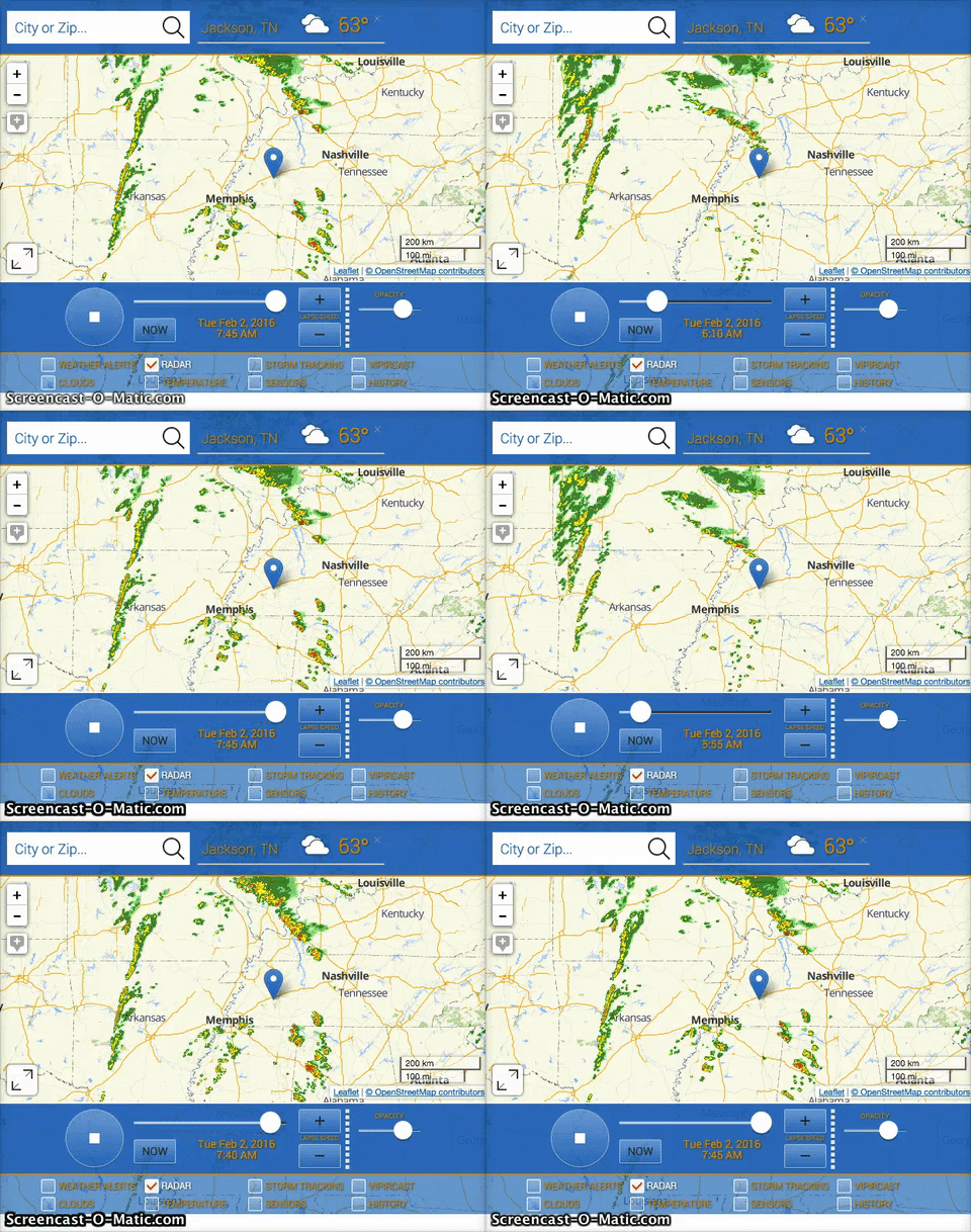
What frustrates me to no end is that we don't have a reliable weather app for our viewers to use today. You can still get alerts pushed to your smartphone on the WBBJ 7 Eyewitness News app but there is not currently a way for you to track the storms on your smartphone through the app.

However, our desktop version of the interactive radar DOES work, and it works very well! On your laptop or desktop computer you can go to www.wbbjtv.com/weather/interactive-radar/ and track storms live there.


In summary, here's the QUICK VERSION:

  • The timeframe for the main threat for severe storms in West Tennessee is now from late afternoon through late evening (4pm to 10pm or later).
  • This would keep most of the storms from arriving until after school dismissal.
  • We could get a few showers and possibly a thunderstorm before then to help limit the energy in the atmosphere.
  • If there's still a sufficient amount of energy in the atmosphere after that (which is looking more likely) we'll need to be on guard for a few tornadoes and damaging winds this afternoon.
  • Tracking storms isn't available on our app but you can use a desktop or laptop computer to do that here.
Stay weather aware today, especially this afternoon and evening. Make sure you have a reliable way to get warnings today whether that be through our app or your NOAA Weather Radio. 

- Tom

Monday, February 1, 2016

Severe Weather Possible Tuesday (2/2/16): MidDay Update

NOTE: This blog post is pertaining to a risk for severe weather that is forecast for Tuesday, February 2, 2016. Revisions to this forecast may be necessary so keep an eye out for updates. If you're short on time, head to the bottom for the quick version.


I mentioned earlier this morning that it looked like the threat was shifting east for severe weather on Tuesday, February 2nd. Right now, West Tennessee is still under a medium risk for severe weather for Tuesday.

I'm still getting some questions about TorCon (a tornado threat parameter from The Weather Channel) and the threat for tornadoes Tuesday so let me address that first. The animated image below shows you something similar to a TorCon - areas in yellow highlight where the threat for tornadoes could be from 12pm to 9pm on Tuesday. That being said, the threat still doesn't really give us more than a low to low-medium risk for tornadoes tomorrow. I'm holding to the forecast for a possibility for "weak" and brief tornadoes to be possible but nothing similar to what happened in West Tennessee on February 5th, 2008.


There's a best case scenario for tomorrow and a worst case. The best case scenario is that we get rain before lunchtime on Tuesday and that helps limit the amount of energy for storms giving us not much more than some thunderstorms that could have a few isolated incidents of damaging winds. The worst case is that there's a significant amount of energy available for these storms that will form sometime in the later morning - some as tornadoes - and developing into large areas of damaging winds. Either situation is entirely possible but I'm starting to lean toward the best case scenario. In both scenarios, Tuesday will be a very warm, wet, and windy day.

In summary, here's the QUICK VERSION:

  • Tuesday is going to be a warm and windy day with a likely chance for rain no matter what.
  • The best case scenario is that West Tennessee doesn't have a lot of energy for severe storms resulting in scattered thunderstorms during the afternoon- some of which may contain damaging winds (leaning toward this one).
  • The worst case scenario is that West Tennessee gets a significant amount of energy resulting in some widespread areas of damaging winds and a few brief tornadoes.
  • Best chance for severe weather would be sometime between the late morning and evening (around 12pm to 9pm).

As always, stay weather-aware, prepare, and feel free to share!

- Tom

Severe Weather Possible Tuesday (2/2/16)

NOTE: This blog post is pertaining to a risk for severe weather that is forecast for Tuesday, February 2, 2016. As always, revisions to this forecast will be necessary so keep an eye out for updates. If you're short on time, head to the bottom for the quick version.


As of 1:00 a.m. Monday, February 1st, the Storm Prediction Center with the National Weather Service has continued a medium risk for severe weather in West Tennessee on Tuesday, February 2nd. It's worth noting that the area of enhanced risk has shifted slightly east, something I suspect may continue in later outlooks.

First of all, Tuesday is going to be warm - you might even call it hot! While Monday will be slightly cooler than Sunday was, warm air will come back. Below is a model forecast for temperatures - 70s look likely in parts of West Tennessee.


One of the main things we watch in a forecast for severe weather is energy and there should be a sufficient amount of it for severe thunderstorms. In the image below, areas in blue are for a high of energy for winter-time. Don't focus so much on where that energy is on the map but rather as much as how high it could be. However, it's also possible that storms forming ahead of the main area of risk will limit the amount of energy we get causing severe weather to become less likely. It's an important piece of the recipe and we'll have to monitor this closely.


Right now, we have a high amount of confidence in West Tennessee getting a lot of rain on Tuesday - especially those areas near the Tennessee River. Currently, I think most of the area has a good chance to see 0.50" to 1" or more fall from Tuesday morning through evening.


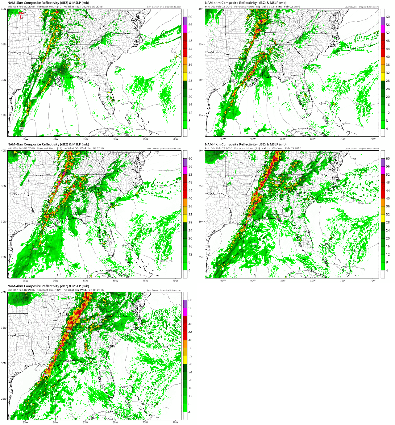
As far as timing is concerned, the four images below outline the basic development of the storms on Tuesday. They show 12pm, 3pm, 6pm and 9pm. Our confidence is increasing on the main threat for severe weather taking place from later in the morning through the evening - say around 9am to 9pm. We'll get a better idea for that timeline on Monday, especially by the 10pm newscast.


Finally, just because this does fall on the first Tuesday of the month of February I know a lot of people are concerned with a threat for tornadoes given what happened here on February 5th, 2008. I'll say this - this forecast setup doesn't resemble what was forecast that day at all. However, "weak" and brief tornadoes will be possible. The map below shows an area in yellow that highlights a low to moderate value for a tornado risk. I'd be more concerned if I saw any red or maroon show up on the map.


In summary, here's the QUICK VERSION:

  • On Tuesday - all of West Tennessee needs to be prepared for severe weather but especially if you live near the Tennessee River.
  • Storms will start in the later hours of the morning and advance eastward through the afternoon and evening.
  • The severe weather threat is increasing but it's certainly not guaranteed. Things can still change.
  • Tornadoes look possible, but we're not expecting a major tornado outbreak - the main threat will be with damaging winds, flash flooding, and large hail.
Stay aware, prepare, and feel free to share!

- Tom