NOTE: This blog post is pertaining to a chance for severe weather that is forecast for the NIGHT of Wednesday, March 30th and early MORNING of Thursday, March 31st. In addition, this post discusses the chance for severe weather that is forecast for the AFTERNOON and EVENING of Thursday, March 31st.
I'll begin with what we know right now, and that is that West Tennessee is under a marginal (1 out of 5) to slight (2 out of 5) risk for severe weather from right now, through 7 a.m. Thursday morning.
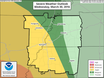
From 7 a.m. Thursday to Thursday evening, West Tennessee is under an enhanced (3 out of 5) risk for severe weather.
This means that there will be a low to low-medium chance for strong to severe thunderstorms tonight mainly near the Mississippi River (points southwest of Jackson) but on Thursday all of West Tennessee has a medium risk for severe weather.
Rain will begin to appear over West Tennessee during this (Wednesday) afternoon and evening. Short term model data is pointing to that and has been for some time. Severe weather is unlikely at this time but a thunderstorm could take shape. Below you'll see how the rain is scattered at the beginning of the loop (during the evening) but late at night (9pm Wednesday into early Thursday morning) the rain becomes more widespread and HEAVY. Plus, the risk for severe weather increases slightly.
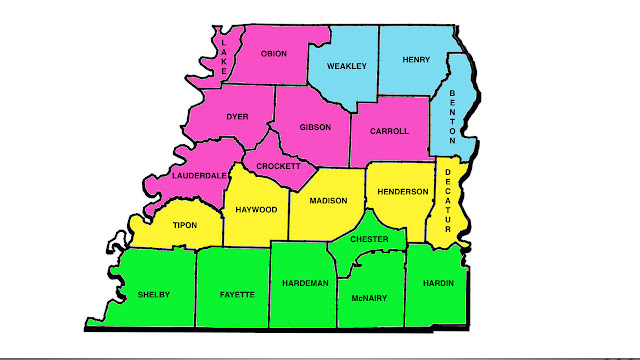
There is a FLASH FLOOD WATCH in effect for much of southwest Tennessee. The counties colored in green are under the watch because they have a chance for 2"-4" of rain to fall over the next 36 to 48 hours. Some may see even more than that. (Sorry the image is a little blurry)
Flooding is the main concern for West Tennessee Wednesday night into Thursday morning. However, we'll be keeping an eye on the risk for a severe thunderstorm to move into West Tennessee from the southwest where damaging winds, large hail, and an isolated tornado will be possible. This would be likeliest after midnight and into the early morning on Thursday.
The rain will come to an end in West Tennessee sometime after daybreak Thursday, but the risk for severe weather and the chance for rain will return through the afternoon and evening hours.
Yesterday (Tuesday) on WBBJ 7 Eyewitness News, I mentioned that I was uncertain about the timing of the cold front on Thursday. If it came through early, then our risk for severe weather wouldn't be too significant but we would still need to be on alert for Flash Flooding.
I was worried that the front might come in later though, and that continues to appear the direction this weather forecast is heading. Based on that trend, and the available ingredients for storms there will be a risk for damaging winds, large hail, and a few tornadoes in West Tennessee Thursday afternoon and evening.
The calendar says late March, so a discussion regarding a risk for severe weather is not uncommon this time of year. In fact, a recent study of climatology in the Mid-South by the National Weather Service in Memphis revealed that March is the 2nd most active month for deadly tornadoes and the 3rd most active month for all tornadoes.
That said, you absolutely NEED to be weather aware for the next 36 to 48 hours! Make sure you have a way to receive alerts including tornado watches and warnings and all other forms of breaking weather information. Be prepared not scared!
Highlights:
1. Be prepared for Flash Flooding tonight and early Thursday if your area is under a flash flood watch right now.
2. Be prepared for severe weather tonight and early Thursday if you live in an area under a risk for severe weather tonight - especially the area in the slight risk.
3. Be prepared for severe weather Thursday afternoon and evening. In addition to the risk for damaging winds and large hail, a few tornadoes will be possible.
Watch WBBJ 7 Eyewitness news tonight for the latest forecast!
NOTE: This blog post is pertaining to a chance for winter weather that is forecast for Sunday, February 14th.

Over the next 8-10 hours, parts of West Tennessee could be dealing with icy conditions north of I-40. However, many of us may not even start to see any precipitation until tonight. A Winter Weather Advisory is in effect until 6pm tonight for northwest Tennessee.
This morning at 5:00 a.m., radar showed isolated snow showers and a few areas of sleet in northwest Tennessee near the Tennessee-Kentucky border. These showers are moving east-southeast at 30-40 mph.
 The latest short term data has been fairly consistent that areas north of I-40 will see scattered snow and ice through the morning before taking a break around lunch-time and then resuming as just rain later this afternoon.
At 6am, models are suggesting very limited coverage of shower activity in northwest Tennessee. At that time it's a mixture of snow and ice.

By 9am, activity starts becoming more widespread north of I-40 with a mixture of freezing rain (red), sleet (pink), and some snow (blue).

At 12pm noon, some of the ice changes over to rain (green). Notice that a LOT of areas south of I-40 may still not have yet seen ANY rain fall at this point.

By 3pm, all precipitation falling in West Tennessee will have changed to just rain and continues to fall predominantly over northwest Tennessee.

At 6pm, showers are starting to move more throughout West Tennessee starting to spread farther south. All precip is still rain.

Areas like Savannah and Selmer, may possibly only just start to see rain by late tonight around midnight.

So for some of you, it may take a while before you start to see anything come down in your area - especially if you live south of I-40. Otherwise, scattered snow and ice showers will be possible through the morning before changing to all rain early this afternoon.
- Snow and ice falling in northwest Tennessee now (5:00am) but showers will be isolated in nature at first
- Icy road conditions will be possible where snow, sleet, and freezing rain fall today since temperatures are cold enough for it to stick on contact
- All precip may fall as rain from the early afternoon on through the rest of the event that could last into Monday morning.
- Less than 2" of snow is expected near the Tennessee-Kentucky border. Most of West Tennessee won't get any snow at all!
- Light accumulations of freezing rain and sleet will be possible north of I-40 but individual results may vary.
Keep an eye on our Facebook and Twitter accounts today for the latest updates! In the meantime, here's a useful way to check road conditions reported by TDOT --> CLICK ME
NOTE: This blog post is pertaining to a chance for winter weather that is forecast for Sunday, February 14th. Revisions to this forecast may be necessary so keep an eye out for updates. If you're short on time, head to the bottom for the quick version.
A lot are asking about the timeline, so lets start with that...

Now lets look at what we're talking about...
BLUE
You're looking at snow first, but eventually changing over to sleet and freezing rain with rain by Sunday night. 0"-2" of snow forecast for your area before it melts Sunday evening.
PINK
You're looking at snow briefly on Sunday morning but it changes over to ice during the later hours of the morning and afternoon. 0.2" or less of accumulating ice is possible in your area before it melts Sunday evening when precip changes to all rain.
Yellow
You're looking at ice Sunday morning with a trace amount of accumulation. Precip will change over to all rain Sunday afternoon and evening.
Green
This COULD briefly be ice but will mostly be a rain event in your area. Wouldn't be surprised if there was heavy rain at times. 1"-2" of rain will be possible. Isolated thunder perhaps as well.
Travel impacts will be minimal unless you're in a county that's in PINK or BLUE. If that's the case, there could be icy conditions on Sunday morning and afternoon before warmer air moves in during the evening.
REMINDER: This should just be seen as a guide. Weather NEVER follows map boundaries so if you live near a county border, you could get close to both of the conditions expected for your nearby counties.