Friday, January 6, 2017

Snow Day 1/6/2017

NOTE: This blog post is pertaining to the snow that fell today, Friday, January 6th, 2017.

Well here we are Friday morning and many parts of West Tennessee are ending up with more snow than we had forecast this morning or last night! We'll probably end up with 2"-4" by 10am in parts of Jackson which is an inch or two more than the dusting to 2" we had forecast on Good Morning West Tennessee. Areas north of I-40 that were only expected to get a dusting are getting closer to an inch or more. That's also more than the National Weather Service or any TV outlet had forecast so we're all in the same boat. After all, we were all looking at the same data!

Let me explain...

West Tennessee usually has a liquid equivalent ratio of 1" of water equaling 10" of snow. Today, the drier air allowed that ratio to go to 1" of water equaling 15" of snow! That means if this were rain, we would have 0.15" of rain on the ground - not a lot. When the air get drier it becomes much more challenging to forecast snowfall accurately. Forecasting rainfall to the hundredth of an inch is virtually impossible.

I'm sorry if you were planning on sending the kids to school today and made a decision based on our forecast that didn't go well. Hopefully everyone can enjoy a three day weekend and stay inside today.

We'll have a full wrap up of today's snowfall totals coming up on WBBJ!

Saturday, December 17, 2016

UPDATE: Slight Risk for Severe Weather Saturday, Dec. 17th

NOTE: This blog post is pertaining to a chance for severe weather that is forecast for today, Saturday, December 17th, 2016.

Well, here we are! Winter one day, Spring the next! Temperatures have warmed up even quicker than expected reaching near 70°F in some places here at 9:15am thanks to the surprise sunshine we've had this morning. That was something I really wasn't expecting us to have much of today, but it could lead toward a more enhanced risk for severe weather tonight.


We haven't had much rain so far and it doesn't look like we'll see much more in West Tennessee until this afternoon. So if you're trying to get some errands done before the holidays, the morning and early afternoon is going to be the best time to do it because after 3 or 4pm we'll start seeing the risk for severe weather increase.


Right now, there's a slight risk for severe weather in all of West Tennessee for this afternoon and evening. That may be upgraded to an enhanced risk later this morning or afternoon. The main threats are still for damaging winds and flash flooding in any thunderstorms that become severe, but the possibility for an isolated tornado is increasing.


Make sure you have a viable way of receiving alerts on your cell phone in case tornado watches or warnings are issued! Here's one way


Right now, the latest weather models are showing the greatest risk for severe weather in Jackson occurring between 5pm and 9pm. Between 7pm and 8pm, this data shows the temperature in Jackson dropping 15°F!


This animated loop shows you what the radar may look like later today. The strongest storms will start developing in northwest Tennessee this afternoon between 2 and 4pm but may not finally leave West Tennessee near Savannah until between 11pm and 1am.


You'll notice toward the end of the lapse, that an ominous purple color shows up. That's the freezing rain and sleet we'll see on the back edge of the rain as colder air crashes in. We're still not expecting anything significant regarding snowfall tonight. Sure, we might see a few snowflakes but don't expect it to stick much if at all.


Ice, on the other hand, could be a problem, especially for the eastern half of West Tennessee. The image below shows the probability for 0.10" of ice to accumulate. That wouldn't really be enough to cause power lines to come down but could accumulate on elevated roadways and overpasses to create a few slick spots on Sunday morning. In addition to freezing rain and sleet, some puddles of rain could freeze with temperatures in the mid 20s by Sunday morning.


Stay weather-aware today, West Tennessee. We're about to see quite a change over the next several hours!

Summary:


  • Severe weather will be possible today during the later hours of the afternoon and evening. Savannah may still have strong thunderstorms around midnight.
  • Temperatures will drop sharply after the cold front comes through
  • Freezing rain and sleet are a real possibility and could cause some hazardous travel in some areas after midnight into early Sunday morning.

Friday, December 16, 2016

Slight Risk for Severe Weather Saturday, Dec. 17th

NOTE: This blog post is pertaining to a chance for severe weather that is forecast for today, Saturday, December 17th, 2016.

Temperatures have already reached the upper 40s in parts of West Tennessee this afternoon now that we have winds from the south gusting between 20 and 25 miles per hour. If anything, this should tell you that our warm-up has begun and is still forecast to continue into Saturday when high temperatures tomorrow could reach the lower to middle 70s!


The two big question that remain are: 1) Will we get severe thunderstorms Saturday afternoon and evening? and 2) Could the cold air catch up to the rain quickly enough to bring freezing rain, sleet, or snow to West Tennessee?

Here's what we know so far...

The Storm Prediction Center with the National Weather Service has upgraded our risk from marginal (1 out of 5) to slight (2 out of 5) so the possibility for a severe thunderstorm tomorrow is looking more likely than it did yesterday for Mississippi and parts of West Tennessee.
Media preview

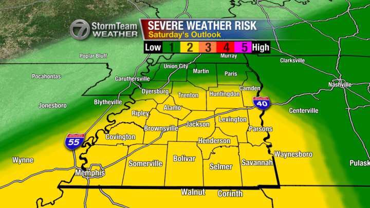
The main threats with any storms that become severe tomorrow are with a possibility for damaging winds and an isolated tornado but flash flooding may also occur now that the ground is more saturated from recent rainfall.

As far as timing is concerned, we'll see rain move into West Tennessee tonight and tomorrow morning but the best chance for any strong to severe thunderstorms will occur between the late afternoon and the late night hours, not ending in Savannah until midnight or 1 a.m. Sunday morning.


You may notice that some of that rain does change over to a wintry mix briefly as the front crosses the Tennessee River. The possibility for West Tennessee to see any freezing rain or sleet is there, but it still does not look like we'll see much if any accumulation. At the very most, there might be a light coating of ice on your car or on tree branches Sunday morning, but with minimal impact to our ability to travel. In Middle Tennessee, the possibility for accumulating ice is higher.

So to summarize:

  • Best possible outcome with our weather this weekend is that we get some wind and rain with a brief period of freezing rain or sleet between Saturday night and Sunday morning.
  • Worst case scenario is that in addition to the wind and rain, we have severe thunderstorms producing an isolated tornado with a brief period of freezing rain or sleet between Saturday night and Sunday morning.
Stay weather aware tomorrow! If you have any errands to run this weekend, Saturday morning and early afternoon will be the best time to get things done! Don't forget to tie down those Christmas decorations down tonight too!

I'll keep you posted with another update on WBBJ 7 Eyewitness News!