Tuesday, January 19, 2016

Snow and Ice Early Wednesday

A Winter Weather Advisory has been issued for all 21 counties of West Tennessee through Wednesday morning. Snow, sleet, and freezing rain are expected to begin moving in the region before sunrise tomorrow before we transition to rain and a wintry mix by lunchtime. Travel could be hazardous in spots and though it won't be impossible, caution is still strongly advised if you have to go out tomorrow. It's possible that some schools may close or delay their opening due to the weather.


Tonight, skies will remain cloudy with temperatures hovering just under freezing even at the coldest point of the night. After midnight, a snow and sleet mix will begin moving into northwest Tennessee with the wintry mix taking over much of the area by 6am. This is going to be a difficult forecast because we may only see rain with some freezing rain mixed in near the Tennessee-Mississippi border, but near the Tennessee-Kentucky border, we may see only snow fall. Every form of winter precipitation is going to be possible in between.
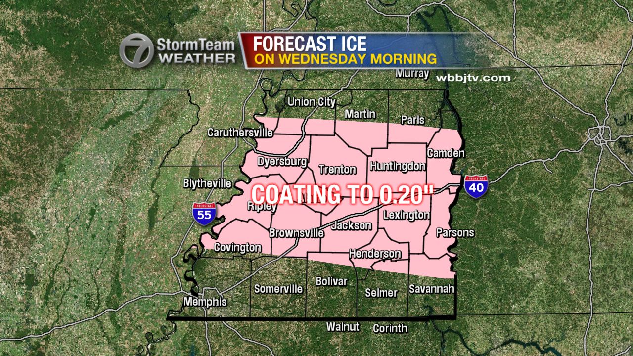


All things considered, travel could be difficult tomorrow, but not impossible. After noon, above freezing temperatures will lead to any accumulations of snow and ice to start melting. Temperatures will reach the mid to upper 30s and low 40s by the afternoon. We'll get a brief break from the wintry mix before rain returns on Thursday afternoon and evening before changing to all snow on Friday morning. It's possible that we once again have accumulation, but this time mainly from snow, ice does not look as likely this time.
 
Stay with the VIPIR 7 Storm Team for future updates to this forecast!

Tuesday, November 17, 2015

Flood and Damaging Wind Threat Tonight

NOTE: This blog post is pertaining to a flooding and damaging wind threat forecast for tonight, the night of Tuesday, November 17, 2015.

An area of low pressure is forcing colder air through the Central and Southern Plains today creating a wide band of showers and thunderstorms that stretch from the Great Lakes to the Gulf Coast. Windy and wet weather are forecast for all of West Tennessee tonight and will last through Wednesday morning. This was a look at the VIPIR 7 Dopplar Radar at 2:17 this afternoon.


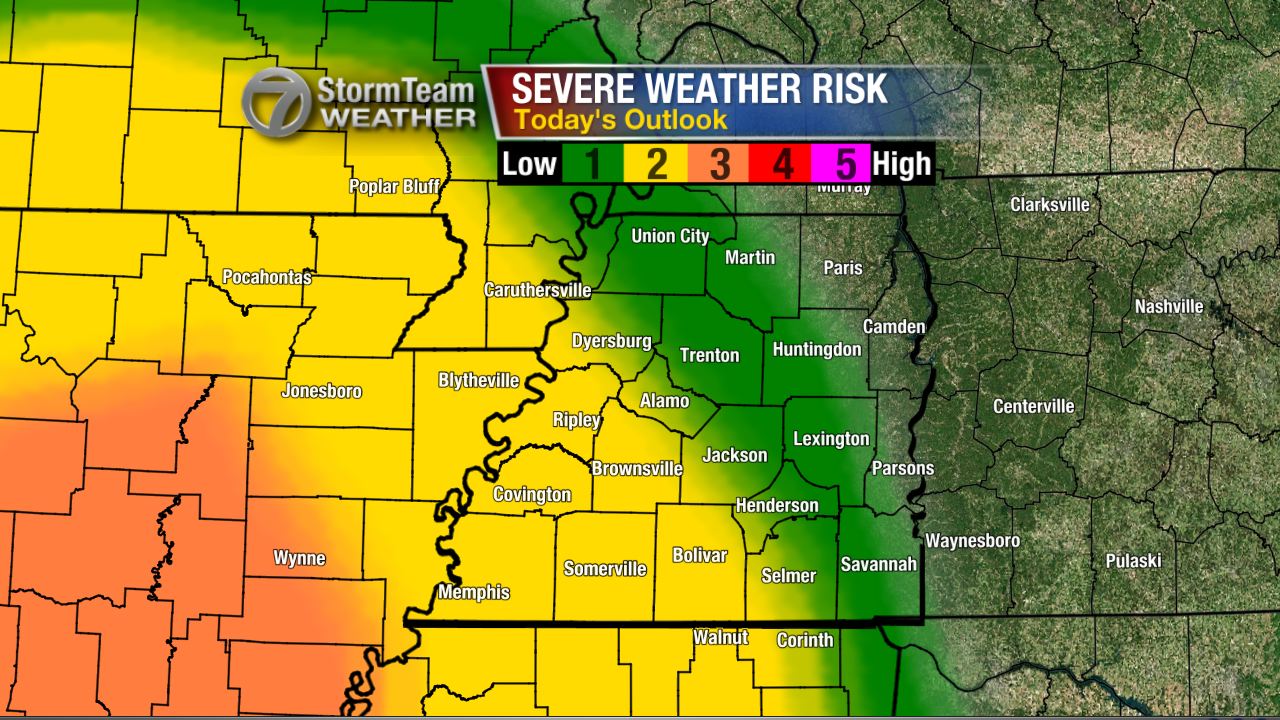
There's a slight risk (2 out of 5 chance) for thunderstorms to become severe in southwest Tennessee tonight posing a threat for localized damaging winds. There's also a low threat for tornadoes which seems to be an event more likely to take shape farther to the south and west of West Tennessee.


The band of heavy rain currently pushing through Louisiana, Arkansas, and Missouri will arrive in the western-most counties of West Tennessee between 9pm and midnight tonight. This band of rain will be moving through the area for a duration of 12 hours, so the slow progression of heavy rain will create a risk for flash flooding - especially in low lying areas with poor drainage.


The winds will be strongest before the rain arrives. A Wind Advisory is in effect for all of West Tennessee tonight into tomorrow morning. Wind gusts will generally be between 30 and 40 mph but could be as high as 50 mph in some spots outside of any thunderstorms.


When the rain arrives, the winds may actually calm down some, but any thunderstorms that become severe could result in wind gusts over 60 mph. The area most likely to see that occur will be in the counties of West Tennessee that border Mississippi and areas south of the TN-MS border.


When the rain is finally over Wednesday morning, we'll be left with an additional 1"-3" of rain on the ground added to the rain most people saw last night. Keep an eye out for flooded roadways on the morning commute, and always remember to find a safer route to your destination if you happen come upon one.


Be safe and keep an eye out for more updates from the VIPIR 7 Storm Team.

Wednesday, November 11, 2015

Severe Weather Risk Tonight

NOTE: This blog post is pertaining to a severe weather threat from the night of Wednesday, November 11, 2015.

Even yesterday, there still seemed to be a decent chance for thunderstorms to become severe near the Mississippi River tonight. The Storm Prediction Center had a slight risk (colored in yellow) for severe weather in western West Tennessee.


Now, that threat is even lower with all of West Tennessee looking at a 1 out of 5 chance or a marginal risk for storms to become severe tonight, but I would contend that that threat is even lower. 


At 9pm tonight (Wednesday), is when I expect storms will be their strongest in West Tennessee which is when a broken line of thunderstorms will be approaching the Mississippi River. After that, storms will continue to become weaker. Most of West Tennessee will have a chance for rain but thunderstorms will NOT be widespread.


If one or two storms DO become severe, the main threat will be with damaging winds. There's very little instability with these storms but there are very strong winds in the upper atmosphere. If any of these winds mix down to the surface, we could have one or two events of downed trees or power lines.


Otherwise, winds will be at their strongest just before the heaviest rain enters West Tennessee. We might see a few power outages as a result of 20 mph winds which VIPIRCast shows over Crockett county and bordering areas. 


Still, this event doesn't look like it'll amount to much more than what we had last Thursday night - a little wind and rain with occasional thunder. I'll be tracking the storms coming up on WBBJ 7 Eyewitness News!