Thursday, April 3, 2014

Severe Weather Potential: April 3 - 4, 2014

After about 3 days of talking about the forecast for severe weather this week, today is finally here. On my walk this morning in North Jackson, the sky was already looking ominous and sunshine was peeking through the clouds.


The National Weather Service in Memphis has issued a Special Weather Statement for all of West Tennessee. You can see the text from that report here. Basically, it aligns with what we've been talking about all week.

The Storm Prediction Center with the National Weather Service has continued our moderate risk for today. As seen below, pretty much all of West Tennessee is under that moderate risk. Everyone in West Tennessee should be prepared for possible severe weather today.

Categorical Risk (West Tennessee - Mainly Moderate)
Tornado Probability (West Tennessee - 10%-15%)
Large Hail Probability (West Tennessee - 30%)
Damaging Wind Probability (West Tennessee - 45%)
It's worth noting that at this point we have our largest threats from damaging winds and large hail with another added threat for tornadoes and heavy rain that could lead to flash flooding.

At 9:42 a.m. today, thunderstorms were already making their way northeast into West Tennessee out of Memphis.


Storms have the potential to become severe as early on as during the mid afternoon and that threat will continue overnight. However, the main threat for severe weather lies with an oncoming cold front that won't be moving into West Tennessee until after midnight. Here's a look at the forecast precipitation rates for 3 a.m. Friday morning.

Rainfall rates close to and above 2"/hr in Jackson
Wind Speeds upwards of 40mph (those are sustained winds, gusts will be higher)
Stay tuned to WBBJ and to the Facebook and Twitter accounts of the VIPIR 7 Storm Team for further updates from the National Weather Service throughout the day! 

Thursday, February 20, 2014

UPDATE: Severe Weather Potential: Thursday February 20th

The latest from the Storm Prediction Center with the National Weather Service:
Text Forecast Here
The Categorical Severe Weather Outlook:
(risk for severe weather indicated in yellow)


Tornado probabilities:


Wind Probabilities:


Hail Probabilities:


All in all, it still seems worth putting an emphasis on the possibility for an isolated tornado tomorrow, but the main threat remains with a change for damaging winds. Strong winds will be in place before storms even arrive tomorrow, but within potentially severe thunderstorms winds gust upwards of 60 miles per hour. Make sure you're prepared in case of a power outage, and keep your weather radio on!

Another look at the latest forecast from one of the latest computer model runs shows that these storms could arrive as soon as noon in northwest Tennessee and make their way east from there with storms taking place while kids are getting out of school and some folks are just getting off work.

Wednesday, February 19, 2014

Severe Weather Potential: Thursday February 20th

For many people in the Mid-South, a forecast high of 75ºF for Thursday, can often do a good job of communicating the threat for severe weather. However, for those of you that might be recent transplants from other parts of the country, tomorrow is going to introduce to you what severe weather can sometimes be like in West Tennessee.

A cold front is going to move across the region tomorrow bringing with it dry and cooler air, but in the meantime, temperatures are going to be VERY mild for this time of the month. In fact, overnight lows may remain in the 60s in Memphis thanks to a warm front crossing West Tennessee overnight bringing warm and moist air with it.


The latest forecast models still show the main threat for severe weather begin with the arrival of showers and thunderstorms out ahead of the cold front. This is expected to take place during the afternoon and evening hours in West Tennessee - right during evening commute.


Damaging winds will be possible in storms that form along a squall line (an elongated line of thunderstorms) with wind gusts upwards of 60 mph. This could result in down tree limbs and loss of power in our area so be prepared with an emergency kit in case that occurs. Still, a wind advisory has already been issued for the area and will go into effect at 9 a.m. and last until 9 p.m. tomorrow. This was issued because tomorrow is expected to be just a generally windy day with wind gusts up to 40 mph and beyond even outside of thunderstorm activity.
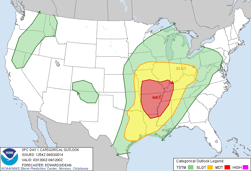
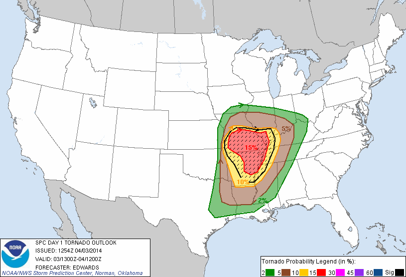


The Storm Prediction Center with the National Weather Service currently (4:30 p.m. Wednesday) has us outlined for a 30% chance for severe weather but they may update that overnight and during the day tomorrow. In addition to strong winds, isolated tornadoes will also be possible.


I'll put out another update in the morning. Stay tuned to WBBJ for more details!