Tuesday, November 17, 2015

Flood and Damaging Wind Threat Tonight

NOTE: This blog post is pertaining to a flooding and damaging wind threat forecast for tonight, the night of Tuesday, November 17, 2015.

An area of low pressure is forcing colder air through the Central and Southern Plains today creating a wide band of showers and thunderstorms that stretch from the Great Lakes to the Gulf Coast. Windy and wet weather are forecast for all of West Tennessee tonight and will last through Wednesday morning. This was a look at the VIPIR 7 Dopplar Radar at 2:17 this afternoon.


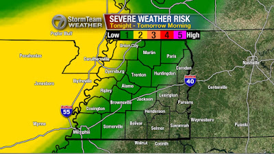
There's a slight risk (2 out of 5 chance) for thunderstorms to become severe in southwest Tennessee tonight posing a threat for localized damaging winds. There's also a low threat for tornadoes which seems to be an event more likely to take shape farther to the south and west of West Tennessee.


The band of heavy rain currently pushing through Louisiana, Arkansas, and Missouri will arrive in the western-most counties of West Tennessee between 9pm and midnight tonight. This band of rain will be moving through the area for a duration of 12 hours, so the slow progression of heavy rain will create a risk for flash flooding - especially in low lying areas with poor drainage.


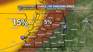
The winds will be strongest before the rain arrives. A Wind Advisory is in effect for all of West Tennessee tonight into tomorrow morning. Wind gusts will generally be between 30 and 40 mph but could be as high as 50 mph in some spots outside of any thunderstorms.


When the rain arrives, the winds may actually calm down some, but any thunderstorms that become severe could result in wind gusts over 60 mph. The area most likely to see that occur will be in the counties of West Tennessee that border Mississippi and areas south of the TN-MS border.


When the rain is finally over Wednesday morning, we'll be left with an additional 1"-3" of rain on the ground added to the rain most people saw last night. Keep an eye out for flooded roadways on the morning commute, and always remember to find a safer route to your destination if you happen come upon one.


Be safe and keep an eye out for more updates from the VIPIR 7 Storm Team.

Wednesday, November 11, 2015

Severe Weather Risk Tonight

NOTE: This blog post is pertaining to a severe weather threat from the night of Wednesday, November 11, 2015.

Even yesterday, there still seemed to be a decent chance for thunderstorms to become severe near the Mississippi River tonight. The Storm Prediction Center had a slight risk (colored in yellow) for severe weather in western West Tennessee.


Now, that threat is even lower with all of West Tennessee looking at a 1 out of 5 chance or a marginal risk for storms to become severe tonight, but I would contend that that threat is even lower. 


At 9pm tonight (Wednesday), is when I expect storms will be their strongest in West Tennessee which is when a broken line of thunderstorms will be approaching the Mississippi River. After that, storms will continue to become weaker. Most of West Tennessee will have a chance for rain but thunderstorms will NOT be widespread.


If one or two storms DO become severe, the main threat will be with damaging winds. There's very little instability with these storms but there are very strong winds in the upper atmosphere. If any of these winds mix down to the surface, we could have one or two events of downed trees or power lines.


Otherwise, winds will be at their strongest just before the heaviest rain enters West Tennessee. We might see a few power outages as a result of 20 mph winds which VIPIRCast shows over Crockett county and bordering areas. 


Still, this event doesn't look like it'll amount to much more than what we had last Thursday night - a little wind and rain with occasional thunder. I'll be tracking the storms coming up on WBBJ 7 Eyewitness News!

Thursday, November 5, 2015

UPDATE: Severe Weather Potential

NOTE: This blog post is pertaining to a severe weather threat from the night of November 5, 2015 into the early morning of Friday, November 6, 2015

We're still tracking a line of strong thunderstorms bringing heavy rain and gusty winds to northwest Arkansas. Right now, there's very little going on with this line that qualifies as severe weather as it pertains to what will impact West Tennessee.


There are severe weather watches currently in effect for locations well to our west including across parts of Missouri and Arkansas. As of 7:46 p.m., no watches have been issued in or near West Tennessee. If they are issued, we'll let you know.


Overall, the threat for severe weather appears even lower than before. As of right now, we're looking at a low risk for any thunderstorms to become severe. If one or two of these storms does exhibit severe characteristics, the main thing to watch out for is still damaging winds. Otherwise it looks like we'll just be dealing with some rain, thunder, and maybe a little wind at times after midnight through Friday morning.


Make sure to tune into WBBJ for the very latest.Be safe, and have a good night!

Severe Weather Potential Overnight

NOTE: This blog post is pertaining to a severe weather threat from the night of November 5, 2015 into the early morning of Friday, November 6, 2015

Above, is the image of what the regional radar was showing at 2:54pm on Friday, November 5th. The area of rain identified by the #1 is rain that is moving northeast into Southeast Missouri - this is not what we're tracking for our risk for severe weather tonight. Instead, we're watching object #2 which is where severe thunderstorm warnings and tornado warnings are currently in place in Oklahoma. #2 is the squall line that will be moving into West Tennessee tonight to bring our chance for bad storms.


The severe weather risk has changed a little from yesterday. The slight risk (2 out of 5 chance) has shifted slightly east indicating a greater chance for severe storms in Union City, Tiptonville, Ridgely, Dyersburg, Ripley, and Covington. The marginal risk (1 out of 5 chance) remains for areas to the east where we may see a strong thunderstorm or two but the risk is low for severe thunderstorms.

Now since I know you're wondering, the answer is yes - there is a small chance for a tornado tonight, especially in the northwest corner of West Tennessee. Though the risk is low, I'll be here all night watching the event in case we see anything that could lead to these thunderstorms producing a tornado.


It's a little more likely that instead of a tornado, we have to deal with severe thunderstorms producing damaging winds. Once again, especially in northwest Tennessee.


 To sum it up, here's a look at the threats for severe weather that could potentially occur tonight and early tomorrow morning. The main focus is on damaging winds and flash flooding. Frequent lightning is also possible in the strong thunderstorms.


On Friday, the threat for strong thunderstorms may redevelop Friday afternoon in areas that get the tail end of tonight's event.


Unfortunately, this may coincide with high school playoff football games. Below, is a map of where home games will be played tomorrow in and around West Tennessee. The kids can play in the rain, but not in lightning. I'm especially concerned with the risk for lightning in Adamsville, Savannah, Waynesboro, and Scotts Hill tomorrow night. Keep an eye on the forecast for future updates!


It's been a long time since we've had a risk for severe weather in West Tennessee. Now, would be a good time to take a deep breath and relax for a second, because this is a relatively low risk for severe weather. I'll be watching this all night so don't panic. Download our app too! That way you can program alerts into your phone if a severe weather is coming to your house.

I'll have more tonight!