NOTE: This blog post is pertaining to the cold air coming with a chance for rain on Wednesday night and Thursday morning, December 7th to December 8th, 2016.
The title of this post seems to be the big question I've been getting in my inbox this weekend. Here we are on December 4th, Christmas Day is 3 weeks away! So where's the snow? Well...
...the interactive radar on our website (www.wbbjtv.com/weather/interactive-radar) shows quite a bit of snow falling over parts of Michigan and the Great Lakes region today. But to really answer your question...

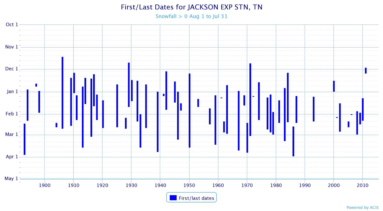
The chart above shows the first and last measurable snowfall dates for Jackson over the years for each winter, dating back to the late 1800s. Each blue bar is drawn for dates between when the first snowfall was recorded to when the last snowfall was recorded. This tells us that, on average, our first snowfall for Winter happens on January 11th and the last snowfall happens on February 5th. You'll notice that there are some years missing so...

Here's a second chart from a different station in Jackson with data going back to the mid 1900s. In this dataset the numbers tell us that, on average, our first snowfall happens on January 5th and the last snowfall happens on February 14th.
In other words, we don't see snow in December very often. We see it more during January and February. Nevertheless, in the last decade (2006-2015) we've had snow in 9 out of 10 Decembers whether that was as few as just one day of that month or 5 days out of that month of measurable snowfall.
Regarding the chance for snow everyone is talking about for later this week, I've been receiving references to forecasts from a certain cable station and from the National Weather Service calling for snow this week on Wednesday night (December 7th) into Thursday morning (December 8th). But there's a reason why we don't get measurable snowfall very often in December. Among many other reasons, one is that the ground is too warm!

Even right now, a website called greencastonline.com shows our soil temperatures in West Tennessee between 40° and 50°F! Snow doesn't stick to that.
The title of this post seems to be the big question I've been getting in my inbox this weekend. Here we are on December 4th, Christmas Day is 3 weeks away! So where's the snow? Well...
...the interactive radar on our website (www.wbbjtv.com/weather/interactive-radar) shows quite a bit of snow falling over parts of Michigan and the Great Lakes region today. But to really answer your question...
The chart above shows the first and last measurable snowfall dates for Jackson over the years for each winter, dating back to the late 1800s. Each blue bar is drawn for dates between when the first snowfall was recorded to when the last snowfall was recorded. This tells us that, on average, our first snowfall for Winter happens on January 11th and the last snowfall happens on February 5th. You'll notice that there are some years missing so...

Here's a second chart from a different station in Jackson with data going back to the mid 1900s. In this dataset the numbers tell us that, on average, our first snowfall happens on January 5th and the last snowfall happens on February 14th.
In other words, we don't see snow in December very often. We see it more during January and February. Nevertheless, in the last decade (2006-2015) we've had snow in 9 out of 10 Decembers whether that was as few as just one day of that month or 5 days out of that month of measurable snowfall.
Regarding the chance for snow everyone is talking about for later this week, I've been receiving references to forecasts from a certain cable station and from the National Weather Service calling for snow this week on Wednesday night (December 7th) into Thursday morning (December 8th). But there's a reason why we don't get measurable snowfall very often in December. Among many other reasons, one is that the ground is too warm!

Even right now, a website called greencastonline.com shows our soil temperatures in West Tennessee between 40° and 50°F! Snow doesn't stick to that.
What we have setting up on Wednesday night into Thursday morning is a slight chance for rain being chased by cold air coming straight down from Alaska. In some cases that rain could change over to snow, but that doesn't look likely for us this time. If it does end up happening, we could see some flurries but nothing that will impact travel too much.
There were definitely times that some of the computer models showed snow sticking on Thursday but there are some problems with these models. More often than not they show nothing sticking for West Tennessee.

So stay with us as we monitor this system. Our job is to prepare - not scare! We're certainly aware of the fact that some people like the idea of snow falling before Christmas (I'm one of them!) but we're not going to just tell you what you want to hear! We want to be accurate and trustworthy for our viewers so that we can be depended upon when weather makes getting out on the roads a hassle.
That's our goal. Thanks for watching!