Thursday, November 5, 2015

UPDATE: Severe Weather Potential

NOTE: This blog post is pertaining to a severe weather threat from the night of November 5, 2015 into the early morning of Friday, November 6, 2015

We're still tracking a line of strong thunderstorms bringing heavy rain and gusty winds to northwest Arkansas. Right now, there's very little going on with this line that qualifies as severe weather as it pertains to what will impact West Tennessee.


There are severe weather watches currently in effect for locations well to our west including across parts of Missouri and Arkansas. As of 7:46 p.m., no watches have been issued in or near West Tennessee. If they are issued, we'll let you know.


Overall, the threat for severe weather appears even lower than before. As of right now, we're looking at a low risk for any thunderstorms to become severe. If one or two of these storms does exhibit severe characteristics, the main thing to watch out for is still damaging winds. Otherwise it looks like we'll just be dealing with some rain, thunder, and maybe a little wind at times after midnight through Friday morning.


Make sure to tune into WBBJ for the very latest.Be safe, and have a good night!

Severe Weather Potential Overnight

NOTE: This blog post is pertaining to a severe weather threat from the night of November 5, 2015 into the early morning of Friday, November 6, 2015

Above, is the image of what the regional radar was showing at 2:54pm on Friday, November 5th. The area of rain identified by the #1 is rain that is moving northeast into Southeast Missouri - this is not what we're tracking for our risk for severe weather tonight. Instead, we're watching object #2 which is where severe thunderstorm warnings and tornado warnings are currently in place in Oklahoma. #2 is the squall line that will be moving into West Tennessee tonight to bring our chance for bad storms.


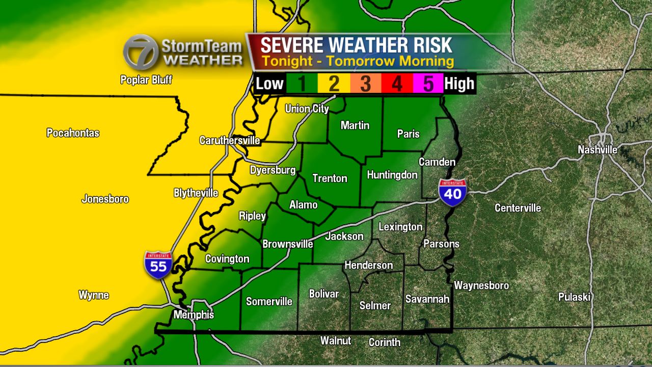
The severe weather risk has changed a little from yesterday. The slight risk (2 out of 5 chance) has shifted slightly east indicating a greater chance for severe storms in Union City, Tiptonville, Ridgely, Dyersburg, Ripley, and Covington. The marginal risk (1 out of 5 chance) remains for areas to the east where we may see a strong thunderstorm or two but the risk is low for severe thunderstorms.

Now since I know you're wondering, the answer is yes - there is a small chance for a tornado tonight, especially in the northwest corner of West Tennessee. Though the risk is low, I'll be here all night watching the event in case we see anything that could lead to these thunderstorms producing a tornado.


It's a little more likely that instead of a tornado, we have to deal with severe thunderstorms producing damaging winds. Once again, especially in northwest Tennessee.


 To sum it up, here's a look at the threats for severe weather that could potentially occur tonight and early tomorrow morning. The main focus is on damaging winds and flash flooding. Frequent lightning is also possible in the strong thunderstorms.


On Friday, the threat for strong thunderstorms may redevelop Friday afternoon in areas that get the tail end of tonight's event.


Unfortunately, this may coincide with high school playoff football games. Below, is a map of where home games will be played tomorrow in and around West Tennessee. The kids can play in the rain, but not in lightning. I'm especially concerned with the risk for lightning in Adamsville, Savannah, Waynesboro, and Scotts Hill tomorrow night. Keep an eye on the forecast for future updates!


It's been a long time since we've had a risk for severe weather in West Tennessee. Now, would be a good time to take a deep breath and relax for a second, because this is a relatively low risk for severe weather. I'll be watching this all night so don't panic. Download our app too! That way you can program alerts into your phone if a severe weather is coming to your house.

I'll have more tonight!

Tuesday, October 13, 2015

One Year Since the Last Tornado Warning

Not that anyone is complaining, but with only 2 weak tornadoes forming in West Tennessee in May, it's been a relatively quiet year for severe weather. The Severe Thunderstorm Warning issued for Henry and Benton counties Monday evening was the first time a warning has been issued in West Tennessee since August 15th. We haven't had a tornado warning issued anywhere in West Tennessee since October 13th - of last year.

This "tornado drought" isn't unprecedented as the past 3 years have had less than 4 tornadoes occur each year in West Tennessee. In the last decade, the largest tornado outbreaks have happened in 2010, 2008, and 2006 when at least 10 tornadoes occurred during each of those years in this area.


However, if you look at it in terms of how many tornado warnings were issued each year over the last decade, 2015 really stands out! There have been 0 tornado warnings issued in West Tennessee in 2015 and that only comes close to 2007 when 5 warnings were issued throughout the entire year.


According to Zachary Maye with the National Weather Service in Memphis, the longest West Tennessee went without a tornado warning was from June 9, 1986 to December 15, 1987 which adds up to 554 days. That number still far surpasses the 365 days we're at now.

West Tennessee is going to be dealing with the effects of El Niño this winter which occurs when temperatures of the water in the Pacific Ocean are warmer than average. The weather in West Tennessee is typically not severe during El 
Niño but as we transition out of El Niño into La Niña, things often become more active. We might see an increase in severe weather next year and in 2017. 

Overall, it doesn't look like we'll be seeing severe weather again in the immediate future but the months of November and December typically see a bump in tornado frequency so it's always best to be prepared just in case!


For now, enjoy the sunshine and the beautiful Fall weekend ahead...