Thursday, January 11, 2018

Winter Storm Watch from Midnight (12 a.m. Friday) to 6 p.m. Friday

NOTE: This blog post is pertaining to a chance for snow and ice that is forecast 
to occur between tonight, Thursday, January 11th, 2018 and Friday, January 12th, 2018.

Over the next 24-36 hours, West Tennessee will see rain transition to freezing rain, then sleet, and finally snow. This will be the first significant impact we'll face this winter season, so it's important that we get prepared today!

SET-UP
Below, is a chart showing the different pressure systems and fronts in the United States as of this morning. Our storm is the "L" in western Oklahoma, and it's attached to a long cold front extending from Mexico to Canada. Both of these features will be in the Mid-South by tonight and will continue to be key players in the forecast throughout the day tomorrow.
Day 1 image not available
Here's an idea for where that low pressure system will go over the next few days. We'll be on the northwest side of the low pressure system Friday morning. That, typically, is where you see the higher snowfall amounts accumulate, but the cold air from the Northern Plains will need to catch up to it quickly enough to cause a change over to snow.


FORECAST
The general trend in the latest model data this morning (Thursday, January 11th 8:00 a.m.) is that we'll be dealing with rain showers (some heavy) off and on throughout the day today into the evening. Between 3 p.m. Thursday afternoon, and 3 a.m. Friday morning, West Tennessee will have some scattered thunderstorms in the Mid-South, but because we won't have a lot of energy in the atmosphere, severe weather remains unlikely.

Animated GIF

West Tennessee generally just has a chance for a few thunderstorms and strong thunderstorms are not likely. However, because of how muggy it is out there, I do expect some pockets of heavy rain to take place this afternoon, evening, and overnight.


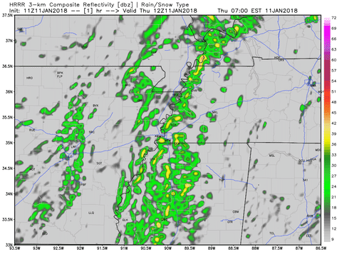
After the cold front starts to move in, we'll change to ice. The animation below (midnight tonight through 9 p.m. Friday) shows that changeover happening in Jackson between 3 a.m. and 6 a.m. Friday. The green color on the map below represents rain, while the reddish and purple colors represent ice, and blue is snow.


The freezing rain and sleet will not be constant Friday morning but could be heavy at times in West Tennessee. Where exactly depends on the path of the storm but I suspect our viewing area will be ground zero for some of the highest ice accumulations. That said, this still doesn't appear to be a major winter storm for the Mid-South. The map below shows only a 30-40% chance for a quarter of an inch of ice to accumulate on Friday in the dark green area.


The trend between yesterday afternoon and this morning also points to lower snowfall totals, but there are still some models putting out high amounts. Again, this all hinges on how quickly the cold air reaches us! Just take a look at this one particular model, the North American Model, and see the differences in output as it's refreshed 5 times since yesterday.


Both in placement, and amounts, this model has not been consistent with where we will get accumulating snow. However, looking at the data from different models as a whole, it still looks like Martin, Huntingdon, Paris, and Camden stand the best chance for the higher totals. The map below shows a 40-50% chance for 2" of snow in the blue area over Weakley, Henry, and Benton counties where the rest of West Tennessee is only looking at a 20-40% chance for that occurring.


After transitioning to snow Friday afternoon, we'll finish all forms of precipitation by Friday evening. 
At this point, I think we're certainly looking at a coating to 2" of snow on grassy surfaces in West Tennessee by the end of the day on Friday. There could be isolated totals of 2"-3" in northwest Tennessee as well, especially for those living near the Tennessee River.

For Jackson, I'm expecting a coating to 2". This graph shows most of this particular family of weather models giving us a minimum of no snow at all to 3-4" but I think that range is an outlier for us right now. The black line represents the model average showing 0.5" of snow.


FINAL DETAILS
I try not to predict unpredictable human behavior, but I'm thinking administrators will issue school closures for tomorrow.

It's worth mentioning that overall, whatever falls from the sky on Friday, will eventually be met with very windy conditions. That means a wind chill at or below 15°F all day long. When those windy conditions with gusts up to 40 miles per hour meet up with ice-laden tree branches, I think we'll have power outages - spotty not widespread. We'll have some sunshine this weekend but below freezing temperatures this weekend with partly to mostly cloudy skies will limit melting over the weekend too.


Summary
  • Rain changes to ice overnight tonight falling by 6 a.m. at the latest for most of West Tennessee. Despite the sharp drop in temperature, severe weather isn't expected overnight but we'll have some thunderstorms.
  • Freezing rain and sleet will be scattered Friday morning before changing to snow Friday afternoon.
  • A coating to 0.25" of freezing rain on tree branches and power lines
  • A coating to 2" of snow is expected with isolated totals of 2"-3" in northwest Tennessee near the Tennessee River are possible (mainly in Weakley, Henry, Benton, and Carroll counties)
  • Friday will be cold and very windy with spotty power outages likely

We'll be updating our snow and ice totals forecast before MidDay and Noon with Meteorologist Moe Shamell, adjusting the timeline for the onset snow and ice, as well as revising the various impacts. Tune in to WBBJ 7 Eyewitness News for the latest forecast!

Wednesday, August 30, 2017

Flash Flood and Severe Weather Potential from Harvey in West Tennessee

NOTE: This blog post is pertaining to a chance for flash flooding and severe weather that is forecast 
to occur between tonight, Wednesday, August 30th, 2017 and Friday, September 1st, 2017.


Over the next 48 hours, an historically unique amount of rainfall is expected to fall in West Tennessee. The showers will be moving in waves as rain bands associated with now Tropical Storm Harvey, soon to be come Tropical Depression Harvey, approaches the area. The forecast continues to evolve based on the new incoming model data and changes will likely be made depending on the path and speed Harvey takes through West Tennessee.


cone graphic

Harvey is now forecast to weaken to a Tropical Depression (maximum sustained winds less than 39 mph) by 7 a.m. Thursday. From there, the storm will move northeast toward West Tennessee, with the storm right overhead late Thursday night and early Friday morning. By 7 a.m. Saturday, the start of Labor Day weekend, the storm will be near Cincinatti, Ohio, far away from our area.


GOES-16 Satellite imagery shows where Harvey is now. Meteorologist Moe Shamell pointed out to me this morning that satellite is starting to show a lot of dry air on the eastern flank of the storm. Not only will this have an impact on rainfall amounts for the eastern portions of our viewing area near the Tennessee River, but it may enhance the potential for tornadoes during the day on Thursday. In the image below, moisture-filled air is shown in blue and green while dry air is shown in orange and yellow.


Regarding the risk for severe weather, out of the threat for tornadoes, damaging winds, or large hail, the main concern will be for a few tornadoes to develop during the day on Thursday. A Tornado Watch may be issued from the National Weather Service sometime Thursday morning. This is not uncommon with a tropical system. On the northeast flank of a cyclone, there is a very high amount of turning of the winds with height that allow for strong rotating updrafts to form brief, but usually weak, tornadoes. Keep an eye out for that Watch to be posted tomorrow.


Of course, beyond a tornado developing, the greatest and most serious concern for our weather over the next 48 hours is the threat of flash flooding. I do not want anyone to think this storm is going to be a repeat of what happened in early May of 2010 nor do I want anyone to think that exactly what happened in Texas or Louisiana is going to happen here in Tennessee, though I know that as hard as I try to dispel that idea, there will still be some who bring it up. Every storm is different, and Harvey will bring its own unique placement and intensity of rainfall.


That said, the totals could break records for daily total rainfall and 3-day total rainfall in the area. Right now, the latest computer model data is putting forecast rainfall totals all over the place in the 21 county area of West Tennessee. Some totals are less than 2" and others are between 6 and 10" for rain falling from now through Saturday morning.


A Flash Flood Watch has been issued for most of West Tennessee (Benton, Carroll, Chester, Crockett, Decatur, Dyer, Fayette, Gibson, Hardeman, Haywood, Henderson, Henry, Lauderdale, Madison, Obion, Shelby, Tipton, and Weakley counties) from 7 p.m. Wednesday through 7 p.m. Friday. 2″-6″ of rain are forecast for most of West Tennessee but with isolated totals of 6″-10″ possible in localized areas. The heaviest rain is forecast to fall from Thursday through early Friday morning.


I think the Madison County Fire Rescue squad said it best on their Facebook page this morning. "...we prepare for the worst and praying for the best."


Prepare now with your family, and have a plan in case flooding or severe weather impacts your day tomorrow. The likelihood of that happening is increasing. There are a TON of resources online freely available to tell you how to start preparations. One of those is the Red Cross.

Power outages, flooded roads, school closures are all on the table tomorrow and Friday. Plan ahead! Lastly here's a simulation for what the storm may look like on radar over the next 48 hours. It begins Wednesday morning and ends Friday evening.


Summary

  • Flash flooding is the main concern. A Flash Flood Watch goes into effect Wednesday night and lasts until Friday night. Most of the area will see 2-6" fall with isolated totals of 6-10" possible. Most of the rain will fall on Thursday.
  • A few tornadoes are possible on Thursday in the Mid-South, mainly near the Tennessee River. A Tornado Watch may be issued tomorrow.
  • Rain will begin to leave the area on Friday before the Labor Day weekend.

We'll be updating our rainfall total forecast tonight, adjusting the time-frame for this event, as well as revising the risk for severe weather. Tune in to WBBJ 7 Eyewitness News tonight for the latest forecast!

Thursday, May 11, 2017

Risk for Severe Weather Tonight (5/11/17)

NOTE: This blog post is pertaining to a chance for severe weather that is forecast 
for tonight, Thursday, May 11th, 2017.

So far so good! Temperatures are in the upper 70s to lower 80s under partly to mostly clear  skies for now. We’ve had a few isolated showers this morning but nothing terribly heavy yet. The main points of discussion in this post are the risk for severe weather later today and tonight, and the chance for scattered showers and thunderstorms on Friday.

Lets talk data…

At the moment, some of the more reliable models still have considerable differences within them, so even though we’re within 24 hours of seeing thunderstorms in West Tennessee, there’s still considerable difficulty pinning down where exactly those storms will be and when.

Here’s a look at the NAM 3km at 10pm…


…and here’s a look at the HRRR at 10pm.


Both models usually perform well, but they disagree on the placement for incoming showers and thunderstorms.  To be a little more specific, some models are allowing the rain to start between 8 and 10 PM but others suggest it could start earlier between 6 and 8 PM.

All of West Tennessee is either under a marginal risk (1 out of 5) or a slight risk (2 out of 5) for severe weather. This is a relatively low risk, but one or two thunderstorms that develop in West Tennessee tonight may become severe. If any thunderstorms do become severe, then we’ll need to be on the lookout for damaging winds and large hail. The chance for a tornado is low tonight.


After this system moves in this evening, the rest of the night and day tomorrow will have scattered showers and thunderstorms into Friday afternoon.


There’s no way to know for sure if it will rain during the West Tennessee Strawberry Festival Grand Floats Parade until tomorrow morning so we’ll prepare for the worst but hope for the best.

Best case scenario: we catch a break in the showers and get through the parade rain-free. Worst case scenario: we have a thunderstorm at 10:00am. Severe weather is even more unlikely tomorrow, so I’m not expecting that. 


So to summarize: 
  • We have a chance for showers and thunderstorms tonight and tomorrow
  • Some thunderstorms could become strong or severe tonight
  • Damaging winds and large hail are possible if any thunderstorms become severe but the tornado threat is low
  • Rain will continue to come and go Friday morning and afternoon, tapering off by sunset